How to use ChatGPT to learn Hydrology - Part II: theory, reasoning and assessment preparation
Estimated reading and practice time: 20-25 minutes.
In IIO422, theoretical assessment prioritises conceptual understanding and reasoning over memorisation or mechanical calculation. Questions may include conceptual problems, numerical exercises, interpretation of graphs and tables, analysis of hydrological situations, error diagnosis, comparison of methods, dimensional analysis, physical interpretation and integrative problems based on real catchments.
Your study strategy should reproduce those demands.

1. Recommended learning cycle
For each topic, use:
diagnosis
→ focused explanation
→ practice
→ correction
→ transfer
→ oral explanation
For example:
I want to study evapotranspiration.

First ask me five diagnostic questions.
Do not explain the topic until I answer.

Then identify my two main conceptual gaps,
correct them and give me two new problems.

Finish with a 90-second oral question.
2. Explicit map of the theoretical content
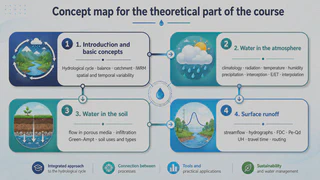
2.1. Introduction and basic concepts
You should understand:
- definition and scope of Hydrology;
- the hydrological cycle;
- the general water-balance equation;
- the concept of a catchment;
- integrated water resources management;
- spatial and temporal variability of hydrological processes.
Definition and scope
Make me explain what Hydrology studies and how it differs
from Meteorology, Hydraulics and Hydrogeology.

Do not accept a one-sentence definition.
Ask for:
1. object of study;
2. scales;
3. processes;
4. engineering applications;
5. one Chilean example.
Hydrological cycle and water balance
Treat a catchment as a control volume.

Make me identify inputs, outputs and storage changes.
Then change the temporal scale from daily to annual
and ask which terms may become small and which need not.
In simplified form:
Inputs - Outputs = Change in storage
or, for a catchment:
P - Q - ET = Delta S
The objective is not to memorise the equation, but to understand what it includes and when the simplification is defensible.
Catchments and integrated water resources management
Compare a river catchment with an administrative boundary.

Ask why a catchment is useful for hydrological analysis
and why integrated water resources management must also consider
users, institutions, infrastructure and ecosystems.
Spatial and temporal variability
Use precipitation, soil moisture and streamflow.

Make me compare their expected spatial and temporal variability
in an Andean catchment and explain why they cannot all be observed
with the same network or resolution.
2.2. Water in the atmosphere
The syllabus includes:
- basic climatology and atmospheric circulation;
- solar radiation;
- air temperature;
- humidity and water vapour;
- precipitation;
- interception;
- evaporation;
- evapotranspiration;
- spatial interpolation of hydrological variables;
- the Budyko framework.
Climatology and atmospheric circulation
Relate atmospheric circulation, topography and precipitation
across Chile.

Make me compare a northern catchment, a Mediterranean catchment
and a southern catchment before giving the explanation.
Radiation, temperature, humidity and water vapour
Build a causal chain:
radiation → temperature → vapour pressure → evaporative demand.

Make me distinguish direct relationships from those
that depend on other variables.
Precipitation
Give me an hourly storm.

Make me distinguish:
- intensity;
- accumulated depth;
- duration;
- temporal resolution;
- antecedent dry period.

Then change only the temporal resolution and ask what information is lost.
Interception
Compare two events with the same total rainfall:
one over a forested catchment and one over sparse vegetation.

Make me reason when interception can be hydrologically important
and when its relative effect becomes smaller.
Evaporation and evapotranspiration
Make me distinguish evaporation, transpiration,
potential ET and actual ET.

Then give one water-limited and one energy-limited situation.
Interpolation
Compare Thiessen polygons, inverse-distance weighting
and kriging for catchment rainfall estimation.

Do not ask which is 'best'.
Give me a station network and make me choose according to
network density, topography, objective, variability and data availability.
Budyko framework
Make me interpret a Budyko diagram.

Ask:
- what the axes represent;
- what water-limited and energy-limited mean;
- what information is required;
- why a deviation does not automatically imply an error.
2.3. Water in the soil
The syllabus includes:
- flow through porous media;
- infiltration;
- Green-Ampt;
- land use and soil types.
Flow through porous media
Make me explain why water can move through unsaturated soil
without reducing the explanation to 'gravity pulls it down'.

Require discussion of gradients and hydraulic properties.
Infiltration
Compare the same storm over an initially dry and an initially wet soil.

Ask me how infiltration, storage, runoff generation
and streamflow response are expected to change.
Green-Ampt
Do not give me the equation first.

Help me reconstruct Green-Ampt from its assumptions:
a distinct wetting front, changes in water content
and capillary forces.

Then show the equation and make me perform dimensional analysis.
Land use and soil types
Compare forest, agricultural land and an urbanised area.

Make me separate the effects of:
- texture;
- structure;
- compaction;
- vegetation cover;
- impervious surfaces.

Do not let me attribute everything to 'soil type'.
2.4. Surface runoff
You should understand:
- hydrological information;
- streamflow measurement;
- hydrographs;
- flow-duration curves (FDCs);
- effective rainfall and direct runoff;
- rainfall-runoff relationships.
Streamflow measurement
Make me distinguish stage measurement, gauging
and streamflow estimation from a rating curve.

Then give me a flood beyond the gauged range
and ask what uncertainty is introduced.
Hydrographs
Show me a hydrograph and make me identify:
baseflow, rising limb, peak, lag, recession and direct-runoff volume.

Do not accept purely geometric descriptions:
require interpretation of processes.
FDCs
Make me interpret Q10, Q50 and Q90.
Include a trap involving exceedance and non-exceedance probability.
Effective rainfall and direct runoff
Give me a storm and hydrograph.
Make me distinguish total rainfall, abstractions,
effective rainfall and direct runoff.
2.5. Simplified hydrological models for annual water balance
The syllabus includes simplified hydrological modelling for catchment-scale annual water balance.
Give me a catchment with P, E and Q time series.

Make me decide what can be estimated directly,
what requires modelling, and which storage components
remain poorly observed.
Do not treat the model as a black box. Ask which assumptions about scale and mass balance are embedded in the model.
2.6. Probabilistic and statistical methods
Conceptually, you should understand:
- exploratory data analysis and descriptive statistics;
- probabilistic treatment of hydrological information;
- frequency and probability functions;
- return period;
- statistical parameters;
- fitting probability distributions;
- probability distributions of hydrological variables.
Make me explain F(x), 1-F(x), exceedance probability,
quantiles and return period using annual maxima.

Do not use equations until the interpretation is clear.
2.7. Rainfall intensities and design
The syllabus includes:
- maximum 24-hour precipitation;
- maximum 1-, 2- and 3-day precipitation;
- Intensity-Duration-Frequency (IDF) curves;
- design hyetographs.
Give me an IDF table.

Make me:
1. select duration and T;
2. convert intensity to depth;
3. explain why intensity and duration are not interchangeable;
4. construct a conceptual design hyetograph;
5. identify one extrapolation limitation.
2.8. Unit hydrographs, design floods and HEC-HMS
The syllabus includes:
- unit and synthetic hydrographs;
- design-flood calculation using SCS-CN;
- introduction to HEC-HMS.
Make me explain the linearity and superposition assumptions
of the unit hydrograph.

Then give me a situation where those assumptions are weak.
For SCS-CN:
Do not give me only the calculation.
Make me interpret how antecedent condition, land use
and CN affect effective rainfall and runoff.
For HEC-HMS:
Explain what each main component of an event-based HEC-HMS model represents
and what information I should check before accepting a simulation.
3. How theory is assessed
Theory = 0.15 × Tests
       + 0.30 × Test 1
       + 0.40 × Test 2
       + 0.15 × Individual Oral Assessment
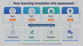
Individual Tests - 15%
Purpose: progressive understanding and continuous study.
Generate a five-question micro-test:
- two conceptual;
- one on units;
- one interpretation;
- one error-diagnosis question.

Ask one at a time.
Test 1 - 30%
Focuses mainly on:
- hydrological processes;
- catchment characterisation;
- annual water balance.
Create a Chilean catchment problem combining
P, ET, Q, storage and physical catchment characteristics.

Assess formulation, units, calculation, interpretation and uncertainty.
Test 2 - 40%
Integrates:
- frequency analysis;
- extreme events;
- design rainfall and streamflow;
- rainfall-runoff relationships;
- hydrological modelling.
Create an integrative problem.

It must force me to combine at least three parts of the course
and justify an engineering decision.
Individual Oral Assessment - 15%
There are two brief individual oral assessments, one after each major test.
Simulate a 6-minute individual oral assessment.

Ask one question at a time.
Require me to:
- explain concepts in my own words;
- relate processes;
- interpret a result;
- justify a decision;
- identify a limitation;
- answer follow-up questions.

Correct me only at the end.
4. Practise the same task types used by the course
Conceptual questions
Make me explain why a 100-year return period
does not mean 'once every 100 years'.
Numerical problems
Assess separately:
formulation, equations, units, calculation and interpretation.
Graph and table interpretation
Practise with:
- time series;
- climographs;
- hydrographs and hyetographs;
- FDCs;
- hydroclimatic maps;
- hypsometric curves;
- Budyko diagrams;
- empirical and theoretical distributions;
- frequency curves;
- IDF curves;
- hydrological-model results.
Error diagnosis
Construct a solution containing exactly three plausible errors:
one conceptual, one dimensional and one methodological.
Do not identify them.
Method comparison
Make me choose only after defining:
objective, data, scale, assumptions, uncertainty and limitations.
Dimensional analysis
Generate expressions involving P, Q, area, volume,
time and intensity.
Make me demonstrate which are dimensionally consistent.
Physical interpretation
After every calculation, ask:
Is the sign plausible?
Is the order of magnitude plausible?
Which process controls this result?
What additional observation would increase confidence?
5. Use ChatGPT to prepare peer discussion
Give me a conceptual multiple-choice question with five options
and exactly one correct answer.

Do not identify the answer.
I will answer first.
Then give me two plausible arguments that another student
might use to defend a different option.
Finally make me answer again.
6. The perturbation technique
Once a problem is solved, change only one condition:
Now double the antecedent soil moisture.
Do not recalculate immediately.
First ask what I expect to change and why.
or:
Keep annual P fixed but change its seasonal distribution.
Which conclusions from the annual water balance still hold?
This reproduces the course sequence: application → perturbation → interpretation → defence.
7. A 25-minute study routine
0-5 min: retrieval without notes.
5-12 min: diagnosis and correction.
12-20 min: new problems and perturbations.
20-25 min: oral explanation and follow-up questions.
Key ideas
- Study in the same way you will be assessed.
- Connect processes rather than memorising chapters.
- Include Budyko, IDF, design hyetographs, SCS-CN and HEC-HMS in your conceptual map.
- Practise with real data and figures from Chilean catchments.
- Require dimensional consistency, interpretation and uncertainty.
- Train explicitly in error diagnosis.
- Practise oral explanations throughout the semester.
- AI may support learning, but it is not permitted during assessments.
Sources
- IIO422-Hydrology course syllabus, Universidad de La Frontera, 2026.
- OpenAI Help: Study Mode
- OpenAI: Study Mode