Papers
Explore peer-reviewed research in hydrology, hydrometeorology, climate extremes, gridded environmental data, and model optimisation. Expand any record without leaving this page.
Featured publications
hydroMOPSO: A flexible and model-independent multi-objective optimisation R package for environmental and hydrological models
Environmental Modelling & Software DOI
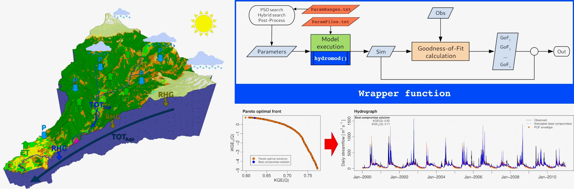
hydroMOPSO is an open-source R package for calibrating hydrological and environmental models using multi-objective optimisation. It works with both R-based and R-external models, offering flexibility and efficient convergence. Tested against existing tools and applied to Andean catchments (TUWmodel, SWAT+ models), it showed strong performance. The package provides clear outputs, helping researchers build more robust and reproducible simulations.
This article introduces hydroMOPSO, a multi-objective, model-independent R package for the calibration of hydrological and environmental models. It supports both R-based and R-external models through wrapper functions, providing flexibility for a wide range of optimisation problems. The package includes fine-tuning options to generate a Pareto-optimal front. The performance of hydroMOPSO was compared to the caRamel R package using benchmark functions and case studies involving two R-based hydrological models in an Andean catchment. hydroMOPSO outperformed caRamel on benchmarks, with faster convergence in the two hydrological models. An R-external case study demonstrated the flexibility and ease of use of hydroMOPSO, through its application to the calibration of the SWAT+ model. The package also enables the generation of informative outputs for modellers, with particular emphasis on hydrographs and parameter sets from the Pareto-optimal front. hydroMOPSO constitutes a valuable tool for researchers and practitioners seeking to implement multi-objective optimisation in environmental and hydrological modelling.
@article{Marinao+al2026,
  title = {{hydroMOPSO}: {A} flexible and model-independent multi-objective optimisation {R} package for environmental and hydrological models},
  author = {Rodrigo Marinao and Mauricio Zambrano-Bigiarini and Oscar M. Baez-Villanueva},
  year = {2026},
  month = {1},
  journal = {Environmental Modelling \& Software},
  volume = {198},
  pages = {106851},
  doi = {10.1016/j.envsoft.2025.106851},
}Marinao, R., Zambrano-Bigiarini, M., & Baez-Villanueva, O. M. (2026). hydroMOPSO: A flexible and model-independent multi-objective optimisation R package for environmental and hydrological models. Environmental Modelling & Software, 198, 106851. https://doi.org/10.1016/j.envsoft.2025.106851
From grid to ground: how well do gridded products represent soil moisture dynamics in natural ecosystems during precipitation events?
Hydrology and Earth System Sciences DOI
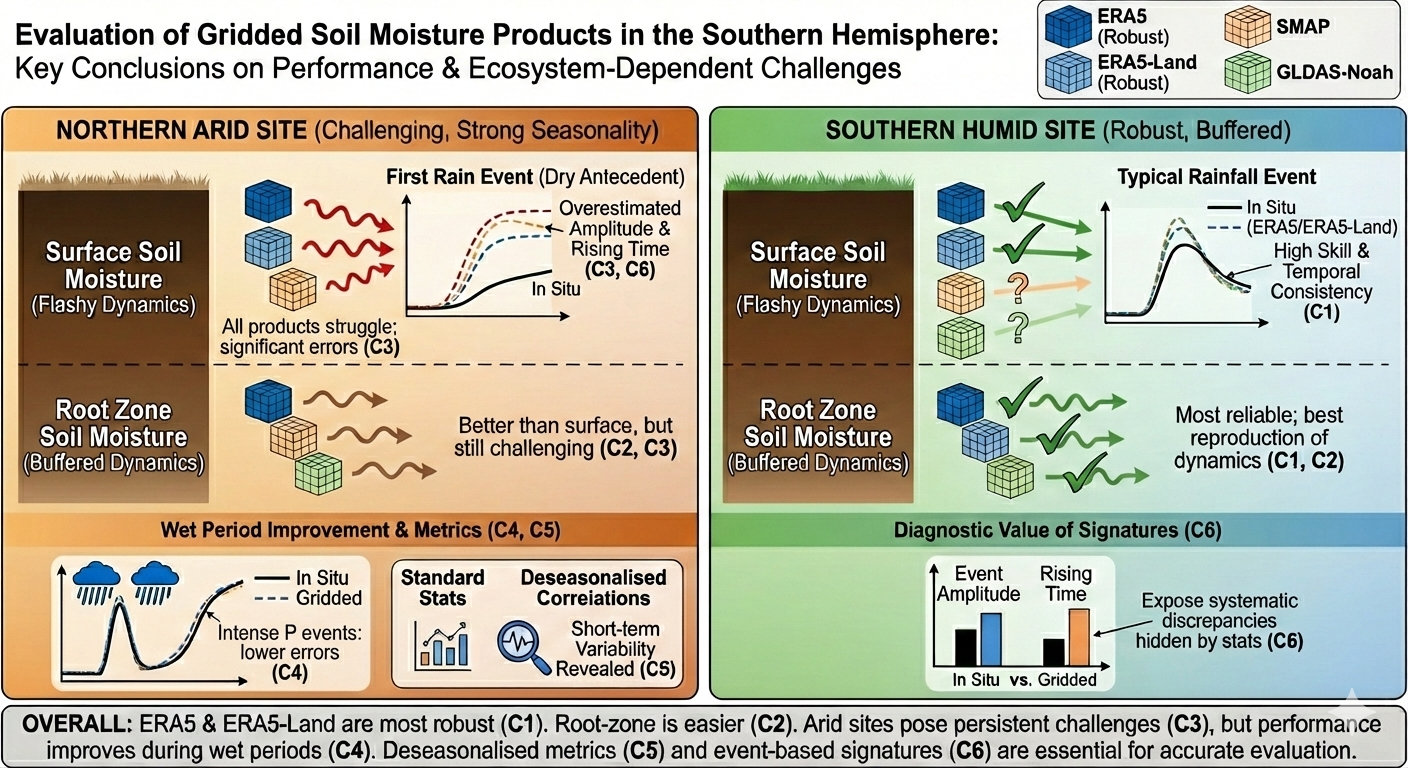
Reliable soil moisture data are essential for understanding land–atmosphere exchanges and hydrological variability, yet their accuracy remains uncertain in many Southern Hemisphere regions. This study evaluated four widely used gridded datasets against field observations across contrasting climates in Chile. Reanalysis-based products performed most consistently overall, while all datasets showed limitations in reproducing soil moisture responses under dry antecedent conditions.
Soil moisture (SM) is a critical variable governing land–atmosphere interactions and influencing ecohydrological and climatic processes. Despite substantial progress in estimating SM through remote sensing and land surface models, considerable uncertainties still remain, especially in near-natural and poorly monitored ecosystems interacting with deeper soil layers. In this study, the performance of four state-of-the-art gridded SM products (SMAP-L4, GLDAS-Noah, ERA5 and ERA5-Land) is evaluated against in situ observations at ten natural monitoring sites in central and southern Chile, covering different hydroclimatic conditions (five semi-arid and five humid sites). The evaluation is performed at a 3-hourly temporal resolution, using well-known statistical metrics of performance, including unbiased root mean square error, modified Kling–Gupta efficiency (KGE′), deseasonalised Spearman's rank correlation coefficient, and percent bias, each applied separately for surface soil moisture (SSM) and root zone soil moisture (RZSM). Finally, the dynamic SM responses to precipitation events is evaluated using rising time and amplitude SM signatures during the first and the most intense precipitation events of the year. Our results show that ERA5 and ERA5-Land consistently outperform SMAP-L4 and GLDAS-Noah on most metrics and in most regions, with ERA5-Land being particularly strong in humid areas. However, SMAP-L4 achieved the best SSM performance in selected northern arid locations, based on KGE′; while GLDAS-Noah performed the worst overall, with the exception of moderate correlation values in southern RZSM. During the first precipitation event of the year, all products systematically overestimated both rising times and amplitudes in the arid north, indicating challenges in capturing SM responses under dry antecedent conditions. In contrast, all the gridded products aligned more closely with in situ measurements during intense precipitation events, particularly in humid regions. Our findings suggest that both ERA5 and ERA5-Land are valuable datasets for monitoring SM variability in near-natural and data-scarce ecosystems, while highlighting the value of event-based SM signatures to complement traditional performance metrics. Finally, we recommend the use of the deseasonalised Spearman rank correlation to better detect inconsistencies in temporal dynamics, especially in regions with strong seasonal cycles, such as arid environments.
@article{Nunez-Ibarra+al2026,
  title = {From grid to ground: how well do gridded products represent soil moisture dynamics in natural ecosystems during precipitation events?},
  author = {Daniel A. N{\a'u}{\~n}ez-Ibarra and Mauricio Zambrano-Bigiarini and Mauricio Galleguillos},
  year = {2026},
  month = {4},
  journal = {Hydrology and Earth System Sciences},
  volume = {30},
  pages = {1813--1847},
  doi = {10.5194/hess-30-1813-2026},
}Núñez-Ibarra, D. A., Zambrano-Bigiarini, M., & Galleguillos, M. (2026). From grid to ground: how well do gridded products represent soil moisture dynamics in natural ecosystems during precipitation events? Hydrology and Earth System Sciences, 30, 1813–1847. https://doi.org/10.5194/hess-30-1813-2026
Developing Intensity-Duration-Frequency (IDF) curves using sub-daily gridded and in situ datasets: characterising precipitation extremes in a drying climate
Hydrology and Earth System Sciences DOI
This study assesses how spatial patterns, temporal trends, and record length in hourly precipitation data affect annual maximum intensities estimated with stationary and non-stationary models across a climatically and topographically diverse region. Comparing five gridded datasets, we find consistent spatial patterns but notable differences in intensities, with non-stationary estimates generally slightly lower.
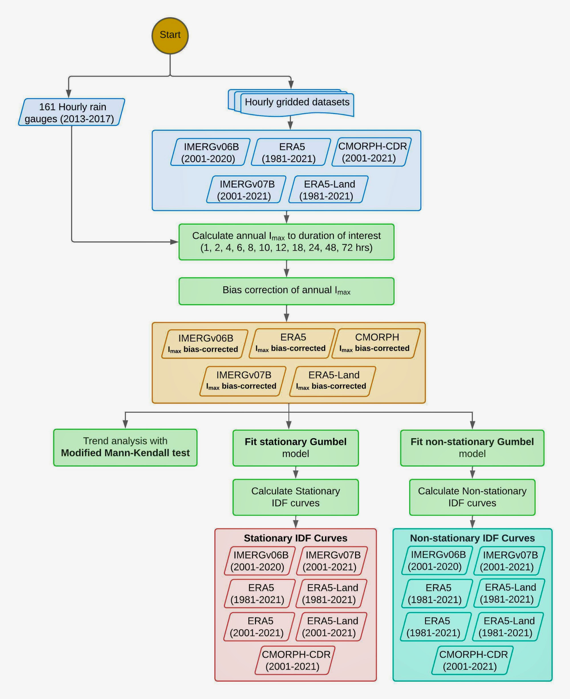
Traditionally, Intensity-Duration-Frequency (IDF) curves are based on rain gauge data under the assumption of stationarity. However, only limited long time series of sub-daily precipitation data are available worldwide, making it difficult to accurately estimate precipitation intensity for different durations and return periods, while climate change is challenging stationarity. This study aims to better understand how the stationary assumption and data length of hourly precipitation data influence the annual maximum intensities of precipitation events in continental Chile, a region with varying climate and topography that has been affected by an unprecedented drought since 2010. Five hourly gridded precipitation datasets (IMERGv06B, IMERGv07B, ERA5, ERA5-Land, CMORPH-CDR) and 161 quality-checked rain gauges are used to compute annual maximum intensities (Imax, mm h−1) using the stationary and non-stationary Gumbel distribution for six return periods (2–100 years) and 11 durations (1–72 h). Bias-correction factors are applied to match the gridded Imax values with the in situ ones, and the modified Mann–Kendall test is used to assess the trends in Imax. Annual maximum intensities are calculated for the 20 year period (2001–2021) for all products, while an additional 40 year period (1981–2021) is used for ERA5 and ERA5-Land to assess the impact of data length. Our results revealed significant decreasing trends across Chile for CMORPH-CDR, decreasing trends in Central-Southern Chile (32–43° S) for ERA5 and ERA5-Land, and isolated, divergent trends for IMERGv06B and IMERGv07B. In addition, our results show that the annual maximum intensities derived from stationary and non-stationary models (Imax) reached its highest values in central and southern Chile, for all durations and return periods, in contrast to the spatial pattern of mean annual precipitation, which increases steadily towards the south. For durations of 24 h or more, the highest intensities are primarily found in the Andes, particularly between the Maule and Araucanía region (35–40° S). While the Imax values were similar for IMERGv07B, ERA5 and ERA5-Land, they were much higher for IMERGv06B and CMORPH-CDR. The difference between stationary and non-stationary Imax values ranges from 0 to 5 mm h−1 and become smaller for durations greater than 8 h. Despite the differences observed in the Gumbel parameters for ERA5 and ERA5-Land when using 20- and 40 year records, the resulting Imax values showed differences with median values below 1 mm h−1. The Imax values are available on a public and user-friendly web platform (https://curvasIDF.cl/, last access: 18 December 2025).
@article{Soto-Escobar+al2026,
  title = {Developing {Intensity}-{Duration}-{Frequency} ({IDF}) curves using sub-daily gridded and in situ datasets: characterising precipitation extremes in a drying climate},
  author = {Crist{\a'o}bal Soto-Escobar and Mauricio Zambrano-Bigiarini and Violeta Tolorza and Ren{\a'e} Garreaud},
  year = {2026},
  month = {1},
  journal = {Hydrology and Earth System Sciences},
  volume = {30},
  number = {1},
  pages = {91--117},
  doi = {10.5194/hess-30-91-2026},
}Soto-Escobar, C., Zambrano-Bigiarini, M., Tolorza, V., & Garreaud, R. (2026). Developing Intensity-Duration-Frequency (IDF) curves using sub-daily gridded and in situ datasets: characterising precipitation extremes in a drying climate. Hydrology and Earth System Sciences, 30(1), 91–117. https://doi.org/10.5194/hess-30-91-2026
Hydropedological clustering: improving the representation of low streamflows in a semi-distributed hydrological model
Journal of Hydrology DOI
Low river flows are critical for water supply in Mediterranean regions, but difficult to simulate because soils control how water is stored and released. This study shows that improving the representation of soil data, using a new hydropedological clustering approach, enhances low-flow simulations in a Chilean catchment. The results highlight that better soil representation leads to more reliable water assessments under drought-prone conditions.
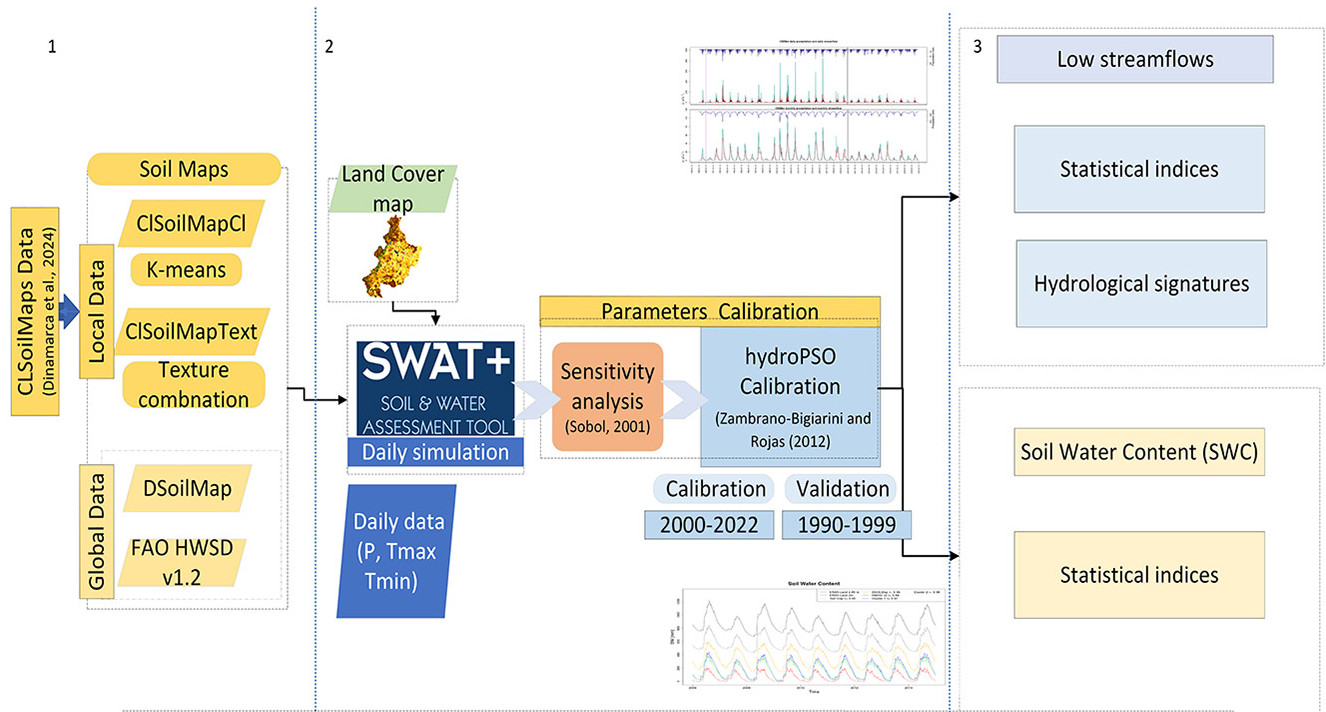
Low streamflows are critical for sustaining water supply in Mediterranean regions, yet their simulation remains challenging due to the complex influence of soils on subsurface water storage and release. This study evaluates how different soil datasets and classification approaches affect the performance of the semi-distributed, physically based SWAT+ model in simulating low streamflows and soil water content (SWC). Using the Mediterranean Cauquenes catchment in central Chile, we compared two global soil datasets (HWSDv1.2, DSOLMap) and two locally derived products (CLSoilMapsTex, CLSoilMapsCl). The latter implements a new hydropedological clustering approach based on Ks, AWC, and $\alpha$. Results show that CLSoilMapsCl substantially improved low streamflow simulations ( = 0.67, 44 % higher than HWSDv1.2) and reproduced hydrological signatures more accurately. These findings highlight that integrating hydropedological information enhances the representation of soil–water interactions in SWAT+, supporting more reliable low streamflow modeling and water-resource assessments in Mediterranean catchments.
@article{Gimeno+al2026,
  title = {Hydropedological clustering: improving the representation of low streamflows in a semi-distributed hydrological model},
  author = {Fernando Gimeno and Mauricio Zambrano-Bigiarini and Camila Alvarez-Garreton and Mauricio Galleguillos},
  year = {2026},
  month = {1},
  journal = {Journal of Hydrology},
  volume = {667},
  pages = {134787},
  doi = {10.1016/j.jhydrol.2025.134787},
}Gimeno, F., Zambrano-Bigiarini, M., Alvarez-Garreton, C., & Galleguillos, M. (2025). Hydropedological clustering: improving the representation of low streamflows in a semi-distributed hydrological model. Journal of Hydrology, 667, 134787. https://doi.org/10.1016/j.jhydrol.2025.134787
2026
hydroMOPSO: A flexible and model-independent multi-objective optimisation R package for environmental and hydrological models
Environmental Modelling & Software · https://doi.org/10.1016/j.envsoft.2025.106851
hydroMOPSO is an open-source R package for calibrating hydrological and environmental models using multi-objective optimisation. It works with both R-based and R-external models, offering flexibility and efficient convergence. Tested against existing tools and applied to Andean catchments (TUWmodel, SWAT+ models), it showed strong performance. The package provides clear outputs, helping researchers build more robust and reproducible simulations.
This article introduces hydroMOPSO, a multi-objective, model-independent R package for the calibration of hydrological and environmental models. It supports both R-based and R-external models through wrapper functions, providing flexibility for a wide range of optimisation problems. The package includes fine-tuning options to generate a Pareto-optimal front. The performance of hydroMOPSO was compared to the caRamel R package using benchmark functions and case studies involving two R-based hydrological models in an Andean catchment. hydroMOPSO outperformed caRamel on benchmarks, with faster convergence in the two hydrological models. An R-external case study demonstrated the flexibility and ease of use of hydroMOPSO, through its application to the calibration of the SWAT+ model. The package also enables the generation of informative outputs for modellers, with particular emphasis on hydrographs and parameter sets from the Pareto-optimal front. hydroMOPSO constitutes a valuable tool for researchers and practitioners seeking to implement multi-objective optimisation in environmental and hydrological modelling.
@article{Marinao+al2026,
  title = {{hydroMOPSO}: {A} flexible and model-independent multi-objective optimisation {R} package for environmental and hydrological models},
  author = {Rodrigo Marinao and Mauricio Zambrano-Bigiarini and Oscar M. Baez-Villanueva},
  year = {2026},
  month = {1},
  journal = {Environmental Modelling \& Software},
  volume = {198},
  pages = {106851},
  doi = {10.1016/j.envsoft.2025.106851},
}Marinao, R., Zambrano-Bigiarini, M., & Baez-Villanueva, O. M. (2026). hydroMOPSO: A flexible and model-independent multi-objective optimisation R package for environmental and hydrological models. Environmental Modelling & Software, 198, 106851. https://doi.org/10.1016/j.envsoft.2025.106851
From grid to ground: how well do gridded products represent soil moisture dynamics in natural ecosystems during precipitation events?
Hydrology and Earth System Sciences · https://doi.org/10.5194/hess-30-1813-2026
Reliable soil moisture data are essential for understanding land–atmosphere exchanges and hydrological variability, yet their accuracy remains uncertain in many Southern Hemisphere regions. This study evaluated four widely used gridded datasets against field observations across contrasting climates in Chile. Reanalysis-based products performed most consistently overall, while all datasets showed limitations in reproducing soil moisture responses under dry antecedent conditions.
Soil moisture (SM) is a critical variable governing land–atmosphere interactions and influencing ecohydrological and climatic processes. Despite substantial progress in estimating SM through remote sensing and land surface models, considerable uncertainties still remain, especially in near-natural and poorly monitored ecosystems interacting with deeper soil layers. In this study, the performance of four state-of-the-art gridded SM products (SMAP-L4, GLDAS-Noah, ERA5 and ERA5-Land) is evaluated against in situ observations at ten natural monitoring sites in central and southern Chile, covering different hydroclimatic conditions (five semi-arid and five humid sites). The evaluation is performed at a 3-hourly temporal resolution, using well-known statistical metrics of performance, including unbiased root mean square error, modified Kling–Gupta efficiency (KGE′), deseasonalised Spearman's rank correlation coefficient, and percent bias, each applied separately for surface soil moisture (SSM) and root zone soil moisture (RZSM). Finally, the dynamic SM responses to precipitation events is evaluated using rising time and amplitude SM signatures during the first and the most intense precipitation events of the year. Our results show that ERA5 and ERA5-Land consistently outperform SMAP-L4 and GLDAS-Noah on most metrics and in most regions, with ERA5-Land being particularly strong in humid areas. However, SMAP-L4 achieved the best SSM performance in selected northern arid locations, based on KGE′; while GLDAS-Noah performed the worst overall, with the exception of moderate correlation values in southern RZSM. During the first precipitation event of the year, all products systematically overestimated both rising times and amplitudes in the arid north, indicating challenges in capturing SM responses under dry antecedent conditions. In contrast, all the gridded products aligned more closely with in situ measurements during intense precipitation events, particularly in humid regions. Our findings suggest that both ERA5 and ERA5-Land are valuable datasets for monitoring SM variability in near-natural and data-scarce ecosystems, while highlighting the value of event-based SM signatures to complement traditional performance metrics. Finally, we recommend the use of the deseasonalised Spearman rank correlation to better detect inconsistencies in temporal dynamics, especially in regions with strong seasonal cycles, such as arid environments.
@article{Nunez-Ibarra+al2026,
  title = {From grid to ground: how well do gridded products represent soil moisture dynamics in natural ecosystems during precipitation events?},
  author = {Daniel A. N{\a'u}{\~n}ez-Ibarra and Mauricio Zambrano-Bigiarini and Mauricio Galleguillos},
  year = {2026},
  month = {4},
  journal = {Hydrology and Earth System Sciences},
  volume = {30},
  pages = {1813--1847},
  doi = {10.5194/hess-30-1813-2026},
}Núñez-Ibarra, D. A., Zambrano-Bigiarini, M., & Galleguillos, M. (2026). From grid to ground: how well do gridded products represent soil moisture dynamics in natural ecosystems during precipitation events? Hydrology and Earth System Sciences, 30, 1813–1847. https://doi.org/10.5194/hess-30-1813-2026
Developing Intensity-Duration-Frequency (IDF) curves using sub-daily gridded and in situ datasets: characterising precipitation extremes in a drying climate
Hydrology and Earth System Sciences · https://doi.org/10.5194/hess-30-91-2026
This study assesses how spatial patterns, temporal trends, and record length in hourly precipitation data affect annual maximum intensities estimated with stationary and non-stationary models across a climatically and topographically diverse region. Comparing five gridded datasets, we find consistent spatial patterns but notable differences in intensities, with non-stationary estimates generally slightly lower.
Traditionally, Intensity-Duration-Frequency (IDF) curves are based on rain gauge data under the assumption of stationarity. However, only limited long time series of sub-daily precipitation data are available worldwide, making it difficult to accurately estimate precipitation intensity for different durations and return periods, while climate change is challenging stationarity. This study aims to better understand how the stationary assumption and data length of hourly precipitation data influence the annual maximum intensities of precipitation events in continental Chile, a region with varying climate and topography that has been affected by an unprecedented drought since 2010. Five hourly gridded precipitation datasets (IMERGv06B, IMERGv07B, ERA5, ERA5-Land, CMORPH-CDR) and 161 quality-checked rain gauges are used to compute annual maximum intensities (Imax, mm h−1) using the stationary and non-stationary Gumbel distribution for six return periods (2–100 years) and 11 durations (1–72 h). Bias-correction factors are applied to match the gridded Imax values with the in situ ones, and the modified Mann–Kendall test is used to assess the trends in Imax. Annual maximum intensities are calculated for the 20 year period (2001–2021) for all products, while an additional 40 year period (1981–2021) is used for ERA5 and ERA5-Land to assess the impact of data length. Our results revealed significant decreasing trends across Chile for CMORPH-CDR, decreasing trends in Central-Southern Chile (32–43° S) for ERA5 and ERA5-Land, and isolated, divergent trends for IMERGv06B and IMERGv07B. In addition, our results show that the annual maximum intensities derived from stationary and non-stationary models (Imax) reached its highest values in central and southern Chile, for all durations and return periods, in contrast to the spatial pattern of mean annual precipitation, which increases steadily towards the south. For durations of 24 h or more, the highest intensities are primarily found in the Andes, particularly between the Maule and Araucanía region (35–40° S). While the Imax values were similar for IMERGv07B, ERA5 and ERA5-Land, they were much higher for IMERGv06B and CMORPH-CDR. The difference between stationary and non-stationary Imax values ranges from 0 to 5 mm h−1 and become smaller for durations greater than 8 h. Despite the differences observed in the Gumbel parameters for ERA5 and ERA5-Land when using 20- and 40 year records, the resulting Imax values showed differences with median values below 1 mm h−1. The Imax values are available on a public and user-friendly web platform (https://curvasIDF.cl/, last access: 18 December 2025).
@article{Soto-Escobar+al2026,
  title = {Developing {Intensity}-{Duration}-{Frequency} ({IDF}) curves using sub-daily gridded and in situ datasets: characterising precipitation extremes in a drying climate},
  author = {Crist{\a'o}bal Soto-Escobar and Mauricio Zambrano-Bigiarini and Violeta Tolorza and Ren{\a'e} Garreaud},
  year = {2026},
  month = {1},
  journal = {Hydrology and Earth System Sciences},
  volume = {30},
  number = {1},
  pages = {91--117},
  doi = {10.5194/hess-30-91-2026},
}Soto-Escobar, C., Zambrano-Bigiarini, M., Tolorza, V., & Garreaud, R. (2026). Developing Intensity-Duration-Frequency (IDF) curves using sub-daily gridded and in situ datasets: characterising precipitation extremes in a drying climate. Hydrology and Earth System Sciences, 30(1), 91–117. https://doi.org/10.5194/hess-30-91-2026
2025
Technical note: What does the Standardized Streamflow Index actually reflect? Insights and implications for hydrological drought analysis
Hydrology and Earth System Sciences · https://doi.org/10.5194/hess-29-1981-2025
Hydrological droughts affect ecosystems and socioeconomic activities worldwide. Despite the fact that they are commonly described with the Standardized Streamflow Index (SSI), there is limited understanding of what they truly reflect in terms of water cycle processes. Here, we used state-of-the-art hydrological models in Andean basins to examine drivers of SSI fluctuations. The results highlight the importance of careful selection of indices and timescales for accurate drought characterization and monitoring.
Hydrological drought is one of the main hydroclimatic hazards worldwide, affecting water availability, ecosystems, and socioeconomic activities. This phenomenon is commonly characterized by the Standardized Streamflow Index (SSI), which is widely used because of its straightforward formulation and calculation. Nevertheless, there is limited understanding of what the SSI actually reveals about how climate anomalies propagate through the terrestrial water cycle. To find possible explanations, we implemented the Structure for Unifying Multiple Modeling Alternatives (SUMMA) coupled with the mizuRoute routing model in six hydroclimatically different case study basins located on the western slopes of the extratropical Andes and examined correlations between the SSI (computed from the models for 1-, 3-, and 6-month timescales) and potential explanatory variables – including precipitation and simulated catchment-scale storages – aggregated at different timescales. Additionally, we analyzed the impacts of adopting commonly used timescales on propagation analyses of specific drought events – from meteorological to soil moisture and hydrological drought – with focus on their duration and intensity. The results reveal that the choice of timescale for the SSI has larger effects on correlations with explanatory variables in rainfall-dominated regimes compared to snowmelt-driven basins, especially when simulated fluxes and storages are aggregated to timescales longer than 9 months. In all the basins analyzed, the strongest relationships (Spearman rank correlation values over 0.7) were obtained when using 6-month timescales to compute the SSI and 9–12 months to compute the explanatory variables, excepting aquifer storage in snowmelt-driven basins. Finally, the results show that the trajectories of drought propagation obtained with the Standardized Precipitation Index (SPI), the Standardized Soil Moisture Index (SSMI), and the SSI may change drastically with the selection of timescale. Overall, this study highlights the need for caution when selecting standardized drought indices and associated timescales, since their choice impacts event characterizations, monitoring, and propagation analyses.
@article{Lema+al2025,
  title = {Technical note: {What} does the {Standardized} {Streamflow} {Index} actually reflect? {Insights} and implications for hydrological drought analysis},
  author = {Fabi{\a'a}n Lema and Pablo A. Mendoza and Nicol{\a'a}s A. V{\a'a}squez and Naoki Mizukami and Mauricio Zambrano-Bigiarini and Ximena Vargas},
  year = {2025},
  journal = {Hydrology and Earth System Sciences},
  volume = {29},
  number = {8},
  pages = {1981--2002},
  doi = {10.5194/hess-29-1981-2025},
  month = {apr},
}Lema, F., Mendoza, P. A., Vásquez, N. A., Mizukami, N., Zambrano-Bigiarini, M., & Vargas, X. (2025). Technical note: What does the Standardized Streamflow Index actually reflect? Insights and implications for hydrological drought analysis. Hydrology and Earth System Sciences, 29(8), 1981–2002. https://doi.org/10.5194/hess-29-1981-2025
Hyperdroughts in central Chile: drivers, impacts, and projections
Hydrology and Earth System Sciences · https://doi.org/10.5194/hess-29-5347-2025
This study focuses on hyperdroughts (HDs) in central Chile, defined as years with a regional rainfall deficit exceeding 75%. Only five HDs occurred in the last century (1924, 1968, 1998, 2019, 2021), but they caused disproportionate environmental and social impacts. In some systems, the effects were larger than expected from those considering moderate droughts and dependent on the antecedent conditions. HDs have analogs from the remote past, and they are expected to increase in the near future.
Owing to the Mediterranean-like and highly variable climate of western South America, moderate droughts (20 %–30 % precipitation deficit) recur every 3–5 years in central Chile, alternating with wet years. Since 2010, however, this region has experienced a continuous dry spell, including extremely dry conditions in 2019 and 2021, when annual precipitation deficits exceeded 75 %. The substantial lack of rain in those winters resulted in severe environmental impacts (e.g., near collapse of natural forests) and augmented social tensions in the country. Long-term records reveal similar extreme dry conditions in 1924, 1968, and 1998, referred to as hyperdroughts (HDs). The climate drivers, past recurrence, environmental impacts, and social effects of HDs are documented here using station-based hydroclimate observations, meteorological reanalysis, tree-ring-based precipitation reconstructions, satellite-based vegetation products, and interviews with social actors. Large-ensemble climate model outputs are employed to assess changes in the recurrence and intensity of HDs in the near future. This task sheds light on the functioning of the atmosphere–hydrosphere–biosphere–social system in a Mediterranean-like region under extreme events and is timely given the prospect of a drier climate for central Chile during the rest of the 21st century. Overall, we found that the acute impacts of the HDs are modulated by precedent conditions, mainly in those systems with long memory (e.g., groundwater and vegetation) and the social context in which they occur (e.g., rural population fraction). Furthermore, extremely low precipitation causes some systems to react in a way that substantially departs from the climate-response relationship established under more benign conditions, including moderate droughts.
@article{Garreaud+al2025,
  title = {Hyperdroughts in central {Chile}: drivers, impacts, and projections},
  author = {Ren{\a'e} Garreaud and Juan Pablo Boisier and Camila Alvarez-Garreton and Duncan A. Christie and Tom{\a'a}s Carrasco-Escaff and Iv{\a'a}n Vergara and Roberto O. Ch{\a'a}vez and Paulina Aldunce and Pablo Camus and Manuel Suazo-{\a'A}lvarez and Mariano Masiokas and Gabriel Castro and Ariel Mu{\~n}oz and Mauricio Zambrano-Bigiarini and Rodrigo Fuster and Lintsiee Godoy},
  year = {2025},
  journal = {Hydrology and Earth System Sciences},
  volume = {29},
  number = {20},
  pages = {5347--5369},
  doi = {10.5194/hess-29-5347-2025},
  month = {oct},
}Garreaud, R., Boisier, J. P., Alvarez-Garreton, C., Christie, D. A., Carrasco-Escaff, T., Vergara, I., Chávez, R. O., Aldunce, P., Camus, P., Suazo-Álvarez, M., Masiokas, M., Castro, G., Muñoz, A., Zambrano-Bigiarini, M., Fuster, R., & Godoy, L. (2025). Hyperdroughts in central Chile: drivers, impacts, and projections. Hydrology and Earth System Sciences, 29(20), 5347–5369. https://doi.org/10.5194/hess-29-5347-2025
Hydropedological clustering: improving the representation of low streamflows in a semi-distributed hydrological model
Journal of Hydrology · https://doi.org/10.1016/j.jhydrol.2025.134787
Low river flows are critical for water supply in Mediterranean regions, but difficult to simulate because soils control how water is stored and released. This study shows that improving the representation of soil data, using a new hydropedological clustering approach, enhances low-flow simulations in a Chilean catchment. The results highlight that better soil representation leads to more reliable water assessments under drought-prone conditions.
Low streamflows are critical for sustaining water supply in Mediterranean regions, yet their simulation remains challenging due to the complex influence of soils on subsurface water storage and release. This study evaluates how different soil datasets and classification approaches affect the performance of the semi-distributed, physically based SWAT+ model in simulating low streamflows and soil water content (SWC). Using the Mediterranean Cauquenes catchment in central Chile, we compared two global soil datasets (HWSDv1.2, DSOLMap) and two locally derived products (CLSoilMapsTex, CLSoilMapsCl). The latter implements a new hydropedological clustering approach based on Ks, AWC, and $\alpha$. Results show that CLSoilMapsCl substantially improved low streamflow simulations ( = 0.67, 44 % higher than HWSDv1.2) and reproduced hydrological signatures more accurately. These findings highlight that integrating hydropedological information enhances the representation of soil–water interactions in SWAT+, supporting more reliable low streamflow modeling and water-resource assessments in Mediterranean catchments.
@article{Gimeno+al2026,
  title = {Hydropedological clustering: improving the representation of low streamflows in a semi-distributed hydrological model},
  author = {Fernando Gimeno and Mauricio Zambrano-Bigiarini and Camila Alvarez-Garreton and Mauricio Galleguillos},
  year = {2026},
  month = {1},
  journal = {Journal of Hydrology},
  volume = {667},
  pages = {134787},
  doi = {10.1016/j.jhydrol.2025.134787},
}Gimeno, F., Zambrano-Bigiarini, M., Alvarez-Garreton, C., & Galleguillos, M. (2025). Hydropedological clustering: improving the representation of low streamflows in a semi-distributed hydrological model. Journal of Hydrology, 667, 134787. https://doi.org/10.1016/j.jhydrol.2025.134787
2024
PatagoniaMet: A multi-source hydrometeorological dataset for Western Patagonia
Scientific Data · https://doi.org/10.1038/s41597-023-02828-2
Western Patagonia holds one of the world's largest freshwater reserves, yet hydrometeorological research has long been limited by scarce and inconsistent data. This study introduces PatagoniaMet, a new open dataset combining 70 years of quality-controlled ground observations and a daily gridded climate product. By integrating data from Chile and Argentina and applying rigorous validation, this new dataset significantly improves hydrological simulations. PatagoniaMet opens up new opportunities for research and water management in this climatically sensitive region.
Western Patagonia (40–56°S) is a clear example of how the systematic lack of publicly available data and poor quality control protocols have hindered further hydrometeorological studies. To address these limitations, we present PatagoniaMet (PMET), a compilation of ground-based hydrometeorological data (PMET-obs; 1950–2020), and a daily gridded product of precipitation and temperature (PMET-sim; 1980–2020). PMET-obs was developed considering a 4-step quality control process applied to 523 hydrometeorological time series obtained from eight institutions in Chile and Argentina. Following current guidelines for hydrological datasets, several climatic and geographic attributes were derived for each catchment. PMET-sim was developed using statistical bias correction procedures, spatial regression models and hydrological methods, and was compared against other bias-corrected alternatives using hydrological modelling. PMET-sim was able to achieve Kling-Gupta efficiencies greater than 0.7 in 72% of the catchments, while other alternatives exceeded this threshold in only 50% of the catchments. PatagoniaMet represents an important milestone in the availability of hydro-meteorological data that will facilitate new studies in one of the largest freshwater ecosystems in the world.
@article{Aguayo+al2024,
  title = {{PatagoniaMet}: {A} multi-source hydrometeorological dataset for {Western} {Patagonia}},
  author = {Rodrigo Aguayo and Jorge Le{\a'o}n-Mu{\~n}oz and Mauricio Aguayo and Oscar Manuel Baez-Villanueva and Mauricio Zambrano-Bigiarini and Alfonso Fern{\a'a}ndez and Martin Jacques-Coper},
  year = {2024},
  journal = {Scientific Data},
  volume = {11},
  number = {1},
  doi = {10.1038/s41597-023-02828-2},
  month = {jan},
}Aguayo, R., León-Muñoz, J., Aguayo, M., Baez-Villanueva, O. M., Zambrano-Bigiarini, M., Fernández, A., & Jacques-Coper, M. (2024). PatagoniaMet: A multi-source hydrometeorological dataset for Western Patagonia. Scientific Data, 11(1). https://doi.org/10.1038/s41597-023-02828-2
On the timescale of drought indices for monitoring streamflow drought considering catchment hydrological regimes
Hydrology and Earth System Sciences · https://doi.org/10.5194/hess-28-1415-2024
Drought can be measured in many ways, but which indicators best reflect river low flows? Analysing 100 near-natural Chilean catchments, this study compares precipitation, soil moisture, and snow-based drought indices across climates. Results show there is no single best index: the most suitable indicator depends on how quickly a catchment responds to rainfall or snowmelt. Surprisingly, simple precipitation-based indices often outperform soil moisture or snow metrics. Our findings support more reliable drought monitoring, especially in data-scarce regions.
There is a wide variety of drought indices, yet a consensus on suitable indices and temporal scales for monitoring streamflow drought remains elusive across diverse hydrological settings. Considering the growing interest in spatially distributed indices for ungauged areas, this study addresses the following questions: (i) What temporal scales of precipitation-based indices are most suitable to assess streamflow drought in catchments with different hydrological regimes? (ii) Do soil moisture indices outperform meteorological indices as proxies for streamflow drought? (iii) Are snow indices more effective than meteorological indices for assessing streamflow drought in snow-influenced catchments? To answer these questions, we examined 100 near-natural catchments in Chile with four hydrological regimes, using the standardised precipitation index (SPI), standardised precipitation evapotranspiration index (SPEI), empirical standardised soil moisture index (ESSMI), and standardised snow water equivalent index (SWEI), aggregated across various temporal scales. Cross-correlation and event coincidence analysis were applied between these indices and the standardised streamflow index at a temporal scale of 1 month (SSI-1), as representative of streamflow drought events. Our results underscore that there is not a single drought index and temporal scale best suited to characterise all streamflow droughts in Chile, and their suitability largely depends on catchment memory. Specifically, in snowmelt-driven catchments characterised by a slow streamflow response to precipitation, the SPI at accumulation periods of 12–24 months serves as the best proxy for characterising streamflow droughts, with median correlation and coincidence rates of approximately 0.70–0.75 and 0.58–0.75, respectively. In contrast, the SPI at a 3-month accumulation period is the best proxy over faster-response rainfall-driven catchments, with median coincidence rates of around 0.55. Despite soil moisture and snowpack being key variables that modulate the propagation of meteorological deficits into hydrological ones, meteorological indices are better proxies for streamflow drought. Finally, to exclude the influence of non-drought periods, we recommend using the event coincidence analysis, a method that helps assessing the suitability of meteorological, soil moisture, and/or snow drought indices as proxies for streamflow drought events.
@article{Baez-Villanueva+al2024,
  title = {On the timescale of drought indices for monitoring streamflow drought considering catchment hydrological regimes},
  author = {Oscar M. Baez-Villanueva and Mauricio Zambrano-Bigiarini and Diego G. Miralles and Hylke E. Beck and Jonatan F. Siegmund and Camila Alvarez-Garreton and Koen Verbist and Ren{\a'e} Garreaud and Juan Pablo Boisier and Mauricio Galleguillos},
  year = {2024},
  journal = {Hydrology and Earth System Sciences},
  volume = {28},
  number = {6},
  pages = {1415--1439},
  doi = {10.5194/hess-28-1415-2024},
  month = {mar},
}Baez-Villanueva, O. M., Zambrano-Bigiarini, M., Miralles, D. G., Beck, H. E., Siegmund, J. F., Alvarez-Garreton, C., Verbist, K., Garreaud, R., Boisier, J. P., & Galleguillos, M. (2024). On the timescale of drought indices for monitoring streamflow drought considering catchment hydrological regimes. Hydrology and Earth System Sciences, 28(6), 1415–1439. https://doi.org/10.5194/hess-28-1415-2024
Land Management Drifted: Land Use Scenario Modeling of Trancura River Basin, Araucanía, Chile
Land · https://doi.org/10.3390/land13020157
Modeling land use scenarios is critical to understand the socio-environmental impacts of current decisions and to explore future configurations for management. The management of regulations and permits by central and local governments plays an important role in shaping land use, with different complexities arising from site-specific socioeconomic dynamics. In Chile, the complexity is even more evident due to insufficient binding land regulations, fragmented government procedures, and the primacy of cities over rural areas. Yet land use must be managed to support sustainable development. This research integrates several state management dynamics into scenario modeling to support decision making at the basin scale through 2050. We employed a mixed qualitative-quantitative approach using interviews with state officials and local stakeholders as the basis for the Conversion of Land Use and its Effects (CLUE) model, which resulted in three scenarios with spatially explicit maps. Key findings indicate that opportunities for developing normative planning tools are limited, leaving state management without clear direction. However, current management practices can address problematic activities such as second-home projects and industrial monocultures while promoting small-scale agriculture. Scenario modeling is useful for understanding how the specifics that arise from the scalar dynamics of state management affect land use change and how existing management resources can be leveraged to achieve positive outcomes for both the ecosystem and society.
Modeling land use scenarios is critical to understand the socio-environmental impacts of current decisions and to explore future configurations for management. The management of regulations and permits by central and local governments plays an important role in shaping land use, with different complexities arising from site-specific socioeconomic dynamics. In Chile, the complexity is even more evident due to insufficient binding land regulations, fragmented government procedures, and the primacy of cities over rural areas. Yet land use must be managed to support sustainable development. This research integrates several state management dynamics into scenario modeling to support decision making at the basin scale through 2050. We employed a mixed qualitative-quantitative approach using interviews with state officials and local stakeholders as the basis for the Conversion of Land Use and its Effects (CLUE) model, which resulted in three scenarios with spatially explicit maps. Key findings indicate that opportunities for developing normative planning tools are limited, leaving state management without clear direction. However, current management practices can address problematic activities such as second-home projects and industrial monocultures while promoting small-scale agriculture. Scenario modeling is useful for understanding how the specifics that arise from the scalar dynamics of state management affect land use change and how existing management resources can be leveraged to achieve positive outcomes for both the ecosystem and society.
@article{Diaz-Jara+al2024,
  title = {Land {Management} {Drifted}: {Land} {Use} {Scenario} {Modeling} of {Trancura} {River} {Basin}, {Araucanía}, {Chile}},
  author = {Alejandro D{\a'\i}az-Jara and Daniela Manuschevich and Aar{\a'o}n Grau and Mauricio Zambrano-Bigiarini},
  year = {2024},
  journal = {Land},
  volume = {13},
  number = {2},
  pages = {157},
  doi = {10.3390/land13020157},
  month = {jan},
}Díaz-Jara, A., Manuschevich, D., Grau, A., & Zambrano-Bigiarini, M. (2024). Land Management Drifted: Land Use Scenario Modeling of Trancura River Basin, Araucanía, Chile. Land, 13(2), 157. https://doi.org/10.3390/land13020157
HESS Opinions: The unsustainable use of groundwater conceals a 'Day Zero'
Hydrology and Earth System Sciences · https://doi.org/10.5194/hess-28-1605-2024
This opinion paper reflects on the risks of overusing groundwater savings to supply permanent water use requirements. Using novel data recently developed for Chile, we reveal how groundwater is being overused, causing ecological and socioeconomic impacts and concealing a \"Day Zero\" scenario. Our argument underscores the need for reformed water allocation rules and sustainable management, shifting from a perception of groundwater as an unlimited source to a finite and vital one.
Water scarcity is a pressing global issue driven by increasing water demands and changing climate conditions. Based on novel estimates of water availability and water use in Chile, we examine the challenges and risks associated with groundwater (GW) withdrawals in the country's central-north region (27–35° S), where extreme water stress conditions prevail. As total water use within a basin approaches the renewable freshwater resources, the dependence on GW reserves intensifies in unsustainable ways. This overuse has consequences that extend beyond mere resource depletion, manifesting into environmental degradation, societal conflict, and economic costs. We argue that the “Day Zero” scenario, often concealed by the uncertain attributes of GW resources, calls for a reconsideration of water allocation rules and a broader recognition of the long-term implications of unsustainable GW use. Our results offer insights for regions worldwide facing similar water scarcity challenges and emphasize the importance of proactive and sustainable water management strategies.
@article{Alvarez-Garreton+al2024,
  title = {{HESS} {Opinions}: {The} unsustainable use of groundwater conceals a '{Day} {Zero}'},
  author = {Camila Alvarez-Garreton and Juan Pablo Boisier and Ren{\a'e} Garreaud and Javier Gonz{\a'a}lez and Roberto Rondanelli and Eugenia Gay{\a'o} and Mauricio Zambrano-Bigiarini},
  year = {2024},
  journal = {Hydrology and Earth System Sciences},
  volume = {28},
  number = {7},
  pages = {1605--1616},
  doi = {10.5194/hess-28-1605-2024},
  month = {apr},
}Alvarez-Garreton, C., Boisier, J. P., Garreaud, R., González, J., Rondanelli, R., Gayó, E., & Zambrano-Bigiarini, M. (2024). HESS Opinions: The unsustainable use of groundwater conceals a 'Day Zero'. Hydrology and Earth System Sciences, 28(7), 1605–1616. https://doi.org/10.5194/hess-28-1605-2024
Exotic tree plantations in the Chilean Coastal Range: balancing the effects of discrete disturbances, connectivity, and a persistent drought on catchment erosion
Earth Surface Dynamics · https://doi.org/10.5194/esurf-12-841-2024
The Chilean Coastal Range, a biodiverse and water-storing landscape, has faced two centuries of human disturbance and a recent megadrought. This study compares long-term natural erosion rates with recent sediment losses to understand how forestry, wildfires, earthquakes, and declining rainfall interact. Surprisingly, recent erosion appears lower than expected, likely masked by reduced rainfall and streamflow. The findings reveal how human impacts and climate trends can offset each other, while still driving landscape degradation.
The Chilean Coastal Range, located in the Mediterranean segment of Chile, is a soil-mantled landscape with the potential to store valuable freshwater supplies and support a biodiverse native forest. Nevertheless, human intervention has been increasing soil erosion for ∼ 200 years, culminating in the intense management of exotic tree plantations throughout the last ∼ 45 years. At the same time, this landscape has been severely affected by a prolonged megadrought. As a result, this combination of stressors complicates disentangling the effects of anthropogenic disturbances and hydroclimatic trends on sediment fluxes at the catchment scale. In this study, we calculate decennial catchment erosion rates from suspended-sediment loads and compare them with a millennial catchment denudation rate estimated from detrital 10Be. We then contrast both of these rates with the effects of discrete anthropogenic-disturbance events and hydroclimatic trends. Erosion and denudation rates are similar in magnitude on decennial and millennial timescales, i.e., 0.018 ± 0.005 and 0.024 ± 0.004 mm yr−1, respectively. Recent human-made disturbances include logging operations throughout all seasons and a dense network of forestry roads, thereby increasing structural sediment connectivity. Further disturbances include two widespread wildfires (2015 and 2017) and an earthquake with an Mw value of 8.8 in 2010. We observe decreased suspended-sediment loads during the wet seasons for the period 1986–2018, coinciding with declining streamflow, baseflow, and rainfall. The low millennial denudation rate aligns with a landscape dominated by slow diffusive soil creep. However, the low decennial erosion rate and the decrease in suspended sediment disagree with the expected effect of intense anthropogenic disturbances and increased structural (sediment) connectivity. Such a paradox suggests that suspended-sediment loads, and thus respective catchment erosion, are underestimated and that decennial sediment detachment and transport have been masked by decreasing rainfall and streamflow (i.e., weakened hydroclimatic drivers). Our findings indicate that human-made disturbances and hydrologic trends may result in opposite, partially offsetting effects on recent erosion, yet both contribute to landscape degradation.
@article{Tolorza+al2024,
  title = {Exotic tree plantations in the {Chilean} {Coastal} {Range}: balancing the effects of discrete disturbances, connectivity, and a persistent drought on catchment erosion},
  author = {Violeta Tolorza and Christian H. Mohr and Mauricio Zambrano-Bigiarini and Benjam{\a'\i}n Sotomayor and Dagoberto Poblete-Caballero and Sebastien Carretier and Mauricio Galleguillos and Oscar Seguel},
  year = {2024},
  journal = {Earth Surface Dynamics},
  volume = {12},
  number = {4},
  pages = {841--861},
  doi = {10.5194/esurf-12-841-2024},
  month = {jul},
}Tolorza, V., Mohr, C. H., Zambrano-Bigiarini, M., Sotomayor, B., Poblete-Caballero, D., Carretier, S., Galleguillos, M., & Seguel, O. (2024). Exotic tree plantations in the Chilean Coastal Range: balancing the effects of discrete disturbances, connectivity, and a persistent drought on catchment erosion. Earth Surface Dynamics, 12(4), 841–861. https://doi.org/10.5194/esurf-12-841-2024
Disponibilidad y seguridad hídrica en el desarrollo de enfermedades crónicas no transmisibles. ¿ Nuevos factores de riesgo?
Revista médica de Chile · https://doi.org/10.4067/s0034-98872024000500643
Las enfermedades crónicas no transmisibles (ECNT) son una de las principales amenazas para la salud global. Más allá de los factores de riesgo tradicionales, este trabajo destaca un vínculo emergente: la relación entre variabilidad climática, disponibilidad de agua y salud. En un país con alto estrés hídrico como Chile, la escasez y los eventos extremos pueden agravar riesgos sanitarios y profundizar desigualdades. Se plantea integrar hidrología, clima y salud pública para enfrentar de manera conjunta este nuevo desafío.
@article{Petermann-Rocha+al2024,
  title = {Disponibilidad y seguridad hídrica en el desarrollo de enfermedades crónicas no transmisibles. ¿ {Nuevos} factores de riesgo?},
  author = {Fanny Petermann-Rocha and Alonso Pizarro and Gabriela Nazar and Mauricio Zambrano-Bigiarini and Angela Plaza-Garrido and Felipe D{\a'\i}az-Toro and Claudia Troncoso-Pantoja and Andr\textbackslash{\a'{}}es Celis and Daniela Sugg and Carlos Celis-Morales},
  year = {2024},
  journal = {Revista médica de Chile},
  publisher = {SciELO Chile},
  volume = {152},
  number = {5},
  pages = {643--644},
  doi = {10.4067/s0034-98872024000500643},
  month = {oct},
}Petermann-Rocha, F., Pizarro, A., Nazar, G., Zambrano-Bigiarini, M., Plaza-Garrido, A., Díaz-Toro, F., Troncoso-Pantoja, C., Celis, A., Sugg, D., & Celis-Morales, C. (2024). Disponibilidad y seguridad hídrica en el desarrollo de enfermedades crónicas no transmisibles. ¿ Nuevos factores de riesgo? Revista médica de Chile, 152(5), 643–644. https://doi.org/10.4067/s0034-98872024000500643
2023
Panta Rhei benchmark dataset: socio-hydrological data of paired events of floods and droughts
Earth System Science Data · https://doi.org/10.5194/essd-15-2009-2023
As the adverse impacts of hydrological extremes increase in many regions of the world, a better understanding of the drivers of changes in risk and impacts is essential for effective flood and drought risk management. We present a dataset containing data of paired events, i.e. two floods or two droughts that occurred in the same area. The dataset enables comparative analyses and allows detailed context-specific assessments. Additionally, it supports the testing of socio-hydrological models. projects = ANID-PCI NSFC 190018, ANID-FONDAP 1522A0001, ANID-Sequía FSEQ210001
As the adverse impacts of hydrological extremes increase in many regions of the world, a better understanding of the drivers of changes in risk and impacts is essential for effective flood and drought risk management and climate adaptation. However, there is currently a lack of comprehensive, empirical data about the processes, interactions, and feedbacks in complex human–water systems leading to flood and drought impacts. Here we present a benchmark dataset containing socio-hydrological data of paired events, i.e. two floods or two droughts that occurred in the same area. The 45 paired events occurred in 42 different study areas and cover a wide range of socio-economic and hydro-climatic conditions. The dataset is unique in covering both floods and droughts, in the number of cases assessed and in the quantity of socio-hydrological data. The benchmark dataset comprises (1) detailed review-style reports about the events and key processes between the two events of a pair; (2) the key data table containing variables that assess the indicators which characterize management shortcomings, hazard, exposure, vulnerability, and impacts of all events; and (3) a table of the indicators of change that indicate the differences between the first and second event of a pair. The advantages of the dataset are that it enables comparative analyses across all the paired events based on the indicators of change and allows for detailed context- and location-specific assessments based on the extensive data and reports of the individual study areas. The dataset can be used by the scientific community for exploratory data analyses, e.g. focused on causal links between risk management; changes in hazard, exposure and vulnerability; and flood or drought impacts. The data can also be used for the development, calibration, and validation of socio-hydrological models. The dataset is available to the public through the GFZ Data Services.
@article{Kreibich+al2023,
  title = {Panta {Rhei} benchmark dataset: socio-hydrological data of paired events of floods and droughts},
  author = {{Kreibich} and {H.} and {Schr{\"o}ter} and {K.} and Di Baldassarre and {G.} and Van Loon and A. F and {Mazzoleni} and {M.} and {Abeshu} and G. W and {Agafonova} and {S.} and {AghaKouchak} and {A.} and {Aksoy} and {H.} and {Alvarez-Garreton} and {C.} and {Aznar} and {B.} and {Balkhi} and {L.} and {Barendrecht} and M. H and {Biancamaria} and {S.} and {Bos-Burgering} and {L.} and {Bradley} and {C.} and {Budiyono} and {Y.} and {Buytaert} and {W.} and {Capewell} and {L.} and {Carlson} and {H.} and {Cavus} and {Y.} and {Couasnon} and {A.} and {Coxon} and {G.} and {Daliakopoulos} and {I.} and de Ruiter and M. C and {Delus} and {C.} and {Erfurt} and {M.} and {Esposito} and {G.} and {Fran{\c c}ois} and {D.} and {Frappart} and {F.} and {Freer} and {J.} and {Frolova} and {N.} and {Gain} and A. K and {Grillakis} and {M.} and {Grima} and J. O and {Guzm{\a'a}n} and D. A and {Huning} and L. S and {Ionita} and {M.} and {Kharlamov} and {M.} and {Khoi} and D. N and {Kieboom} and {N.} and {Kireeva} and {M.} and {Koutroulis} and {A.} and {Lavado-Casimiro} and {W.} and {Li} and {H.-Y.} and {LLasat} and M. C and {Macdonald} and {D.} and {M{\r a}rd} and {J.} and {Mathew-Richards} and {H.} and {McKenzie} and {A.} and {Mejia} and {A.} and {Mendiondo} and E. M and {Mens} and {M.} and {Mobini} and {S.} and {Mohor} and G. S and {Nagavciuc} and {V.} and {Ngo-Duc} and {T.} and {Nguyen} and H. T. T and {Nhi} and P. T. T and {Petrucci} and {O.} and {Quan} and N. H and {Quintana-Segu{\a'\i}} and {P.} and {Razavi} and {S.} and {Ridolfi} and {E.} and {Riegel} and {J.} and {Sadik} and M. S and {Sairam} and {N.} and {Savelli} and {E.} and {Sazonov} and {A.} and {Sharma} and {S.} and {S{\"o}rensen} and {J.} and {Souza} and F. A. A and {Stahl} and {K.} and {Steinhausen} and {M.} and {Stoelzle} and {M.} and {Szali{\a'n}ska} and {W.} and {Tang} and {Q.} and {Tian} and {F.} and {Tokarczyk} and {T.} and {Tovar} and {C.} and {Tran} and T. V. T and van Huijgevoort and M. H. J and van Vliet and M. T. H and {Vorogushyn} and {S.} and {Wagener} and {T.} and {Wang} and {Y.} and {Wendt} and D. E and {Wickham} and {E.} and {Yang} and {L.} and M. Zambrano-Bigiarini and {Ward} and P. {and J}},
  year = {2023},
  journal = {Earth System Science Data},
  volume = {15},
  number = {5},
  pages = {2009--2023},
  doi = {10.5194/essd-15-2009-2023},
  month = {may},
}Kreibich, H., Schröter, K., Baldassarre, D., G., Loon, V., F, A., Mazzoleni, M., Abeshu, W, G., Agafonova, S., AghaKouchak, A., Aksoy, H., Alvarez-Garreton, …, & J, P. a. (2023). Panta Rhei benchmark dataset: socio-hydrological data of paired events of floods and droughts. Earth System Science Data, 15(5), 2009–2023. https://doi.org/10.5194/essd-15-2009-2023
2022
The challenge of unprecedented floods and droughts in risk management
Nature · https://doi.org/10.1038/s41586-022-04917-5
Flood and drought risk management has reduced vulnerability worldwide, yet overall impacts continue to rise. Analysing 45 pairs of events in the same locations, this study shows that management works for events within past experience but often fails when extremes exceed design limits, such as levee or reservoir capacity. Only where strong governance and sustained investment were in place did impacts decline despite higher hazard levels. The findings warn that unprecedented climate-driven extremes may outpace current risk management systems. projects = ANID-PCI NSFC 190018, ANID-FONDAP 15110009, ANID-Sequía FSEQ210001
Risk management has reduced vulnerability to floods and droughts globally1,2, yet their impacts are still increasing3. An improved understanding of the causes of changing impacts is therefore needed, but has been hampered by a lack of empirical data4,5. On the basis of a global dataset of 45 pairs of events that occurred within the same area, we show that risk management generally reduces the impacts of floods and droughts but faces difficulties in reducing the impacts of unprecedented events of a magnitude not previously experienced. If the second event was much more hazardous than the first, its impact was almost always higher. This is because management was not designed to deal with such extreme events: for example, they exceeded the design levels of levees and reservoirs. In two success stories, the impact of the second, more hazardous, event was lower, as a result of improved risk management governance and high investment in integrated management. The observed difficulty of managing unprecedented events is alarming, given that more extreme hydrological events are projected owing to climate change.
@article{Kreibich+al2022,
  title = {The challenge of unprecedented floods and droughts in risk management},
  author = {Heidi Kreibich and Anne F. {Van Loon} and Kai Schr{\"o}ter and Philip J. Ward and Maurizio Mazzoleni and Nivedita Sairam and Guta Wakbulcho Abeshu and Svetlana Agafonova and Amir AghaKouchak and Hafzullah Aksoy and Camila Alvarez-Garreton and Blanca Aznar and Laila Balkhi and Marlies H. Barendrecht and Sylvain Biancamaria and Liduin Bos-Burgering and Chris Bradley and Yus Budiyono and Wouter Buytaert and Lucinda Capewell and Hayley Carlson and Yonca Cavus and Ana{\"\i}s Couasnon and Gemma Coxon and Ioannis Daliakopoulos and Marleen C. {de Ruiter} and Claire Delus and Mathilde Erfurt and Giuseppe Esposito and Didier Fran{\c c}ois and Fr{\a'e}d{\a'e}ric Frappart and Jim Freer and Natalia Frolova and Animesh K. Gain and Manolis Grillakis and Jordi Oriol Grima and Diego A. Guzm{\a'a}n and Laurie S. Huning and Monica Ionita and Maxim Kharlamov and Dao Nguyen Khoi and Natalie Kieboom and Maria Kireeva and Aristeidis Koutroulis and Waldo Lavado-Casimiro and Hong-Yi Li and Mar{\a'\i}a Carmen LLasat and David Macdonald and Johanna M{\r a}rd and Hannah Mathew-Richards and Andrew McKenzie and Alfonso Mejia and Eduardo Mario Mendiondo and Marjolein Mens and Shifteh Mobini and Guilherme Samprogna Mohor and Viorica Nagavciuc and Thanh Ngo-Duc and Thi Thao {Nguyen Huynh} and Pham Thi Thao Nhi and Olga Petrucci and Hong {Quan Nguyen} and Pere Quintana-Segu{\a'\i} and Saman Razavi and Elena Ridolfi and Jannik Riegel and Md Shibly Sadik and Elisa Savelli and Alexey Sazonov and Sanjib Sharma and Johanna S{\"o}rensen and Felipe Augusto Arguello Souza and Kerstin Stahl and Max Steinhausen and Michael Stoelzle and Wiwiana Szali{\a'n}ska and Qiuhong Tang and Fuqiang Tian and Tamara Tokarczyk and Carolina Tovar and Thi Van Thu Tran and Marjolein H. J. {Van Huijgevoort} and Michelle T. H. {van Vliet} and Sergiy Vorogushyn and Thorsten Wagener and Yueling Wang and Doris E. Wendt and Elliot Wickham and Long Yang and M. Zambrano-Bigiarini and G{\"u}nter Bl{\"o}schl and Giuliano {Di Baldassarre}},
  year = {2022},
  journal = {Nature},
  volume = {608},
  number = {7921},
  pages = {80--86},
  doi = {10.1038/s41586-022-04917-5},
  month = {aug},
}Kreibich, H., Loon, A. F. V., Schröter, K., Ward, P. J., Mazzoleni, M., Sairam, N., Abeshu, G. W., Agafonova, S., AghaKouchak, A., Aksoy, H., Alvarez-Garreton, C., Aznar, B., Balkhi, L., Barendrecht, M. H., Biancamaria, S., Bos-Burgering, L., Bradley, C., Budiyono, Y., Buytaert, W., …, & Baldassarre, G. D. (2022). The challenge of unprecedented floods and droughts in risk management. Nature, 608(7921), 80–86. https://doi.org/10.1038/s41586-022-04917-5
A coupled modeling approach to assess the effect of forest policies in water provision: A biophysical evaluation of a drought-prone rural catchment in south-central Chile
Science of the Total Environment · https://doi.org/10.1016/j.scitotenv.2022.154608
How do forest conservation policies affect water supply? This study combines land-use and ecohydrological modelling to assess impacts in a drought-prone Chilean catchment where rural communities rely on water trucks. Scenarios promoting native forest recovery increased forest cover substantially and produced modest but meaningful gains in dry-season streamflow. These improvements could reduce emergency water delivery costs by hundreds of thousands of dollars per month, highlighting the economic and social value of forest conservation.
The effect of different forest conservation policies on water provision has been poorly investigated due to a lack of an integrative methodological framework that enables its quantification. We developed a method for assessing the effects of forest conservation policies on water provision for rural inhabitants, based on a land-use model coupled with an eco-hydrological model. We used as a case study the Lumaco catchment, Chile, a territory dominated by native forests (NF) and non-native tree farms, with an extended dry period where nearly 12,600 people of rural communities get drinking water through water trucks. We analyzed three land-use policy scenarios: i) a baseline scenario based on historical land-cover maps; ii) a NF Recovery and Protection (NFRP) scenario, based on an earlier implementation of the first NF Recovery and Forestry Development bill; and iii) a Pristine (PR) scenario, based on potential vegetation belts; the latter two based on Dyna CLUE, and simulated between 1990 and 2015. Impacts on water provision from each scenario were computed with SWAT. The NFRP scenario resulted in an increase of 6974 ha of NF regarding the baseline situation, and the PR scenario showed an increase of 26,939 ha of NF. Despite large differences in NF areas, slight increases in inflows (Q) were found between the NFRP and the PR scenarios, with relative differences with respect to the baseline of 0.3% and 2.5% for NFRP and PR, respectively. Notwithstanding, these small differences in the NFRP scenario, they become larger if we analyze the cumulative values during the dry season only (December, January, and February), where they reach 1.1% in a normal year and 3.1% in a dry year. Flows increases were transformed into water truck costs resulting in up to 441,876 USD (monthly) of fiscal spending that could be avoided during a dry period.
@article{Gimeno+al2022,
  title = {A coupled modeling approach to assess the effect of forest policies in water provision: {A} biophysical evaluation of a drought-prone rural catchment in south-central {Chile}},
  author = {Fernando Gimeno and Mauricio Galleguillos and Daniela Manuschevich and Mauricio Zambrano-Bigiarini},
  year = {2022},
  journal = {Science of the Total Environment},
  volume = {830},
  pages = {154608},
  doi = {10.1016/j.scitotenv.2022.154608},
  month = {mar},
}Gimeno, F., Galleguillos, M., Manuschevich, D., & Zambrano-Bigiarini, M. (2022). A coupled modeling approach to assess the effect of forest policies in water provision: A biophysical evaluation of a drought-prone rural catchment in south-central Chile. Science of the Total Environment, 830, 154608. https://doi.org/10.1016/j.scitotenv.2022.154608
2021
Towards best default configuration settings for NMPSO in multi-objective optimization
2021 IEEE Latin American Conference on Computational Intelligence (LA-CCI) · https://doi.org/10.1109/LA-CCI48322.2021.9769844
Real-world optimisation often requires finding good solutions with limited computational effort. This study tests 16 configurations of the NMPSO algorithm to identify settings that achieve fast convergence with few function evaluations. Using benchmark problems and comparisons with leading methods such as NSGA-II and NSGA-III, the results show that a carefully tuned, small-swarm configuration performs best. The selected setup converges quickly toward optimal trade-offs and competes strongly with state-of-the-art algorithms, offering an efficient solution for complex multi-objective problems.
In this work we tested different configuration settings for the NMPSO algorithm, aiming at solving multi-objective optimization problems with a small number of function evaluations, which is an important aspect that must be addressed in real-world optimization problems. Sixteen different configurations were tested for NMPSO, with different combinations of: i) the swarm size, ii) the maximum number of particles in the external archive, and iii) the maximum amount of genetic operations in the external archive. Three DTLZ problems were used to select the best configuration, which was then evaluated against other state-of-the-art multi-objective optimization algorithms (MMOPSO, NSGA-II, NSGA-III). Our results showed that the fastest convergence towards the true Pareto-optimal front is provided by the configuration with a swarm size of 10, a maximum number of particles allowed in the external archive of 100, and a limit of genetic operations per iteration given by 50% of the maximum number of particles allowed in the external archive. The selected configuration was also very competitive or even superior against NSGA-II and NSGA-III, in terms of the number of function evaluations required to start having an HV larger than zero, but also in the HV values achieved after stabilization of the Pareto-optimal front.
@inproceedings{Marinao-RivasZambrano-Bigiarini2021,
  title = {Towards best default configuration settings for {NMPSO} in multi-objective optimization},
  author = {Rodrigo Marinao-Rivas and Mauricio Zambrano-Bigiarini},
  year = {2021},
  booktitle = {2021 {IEEE} {Latin} {American} {Conference} on {Computational} {Intelligence} ({LA}-{CCI})},
  publisher = {IEEE},
  pages = {1--6},
  doi = {10.1109/LA-CCI48322.2021.9769844},
  month = {nov},
}Marinao-Rivas, R., & Zambrano-Bigiarini, M. (2021). Towards best default configuration settings for NMPSO in multi-objective optimization. 2021 IEEE Latin American Conference on Computational Intelligence (LA-CCI), 1–6. https://doi.org/10.1109/LA-CCI48322.2021.9769844
On the selection of precipitation products for the regionalisation of hydrological model parameters
Hydrology and Earth System Sciences · https://doi.org/10.5194/hess-25-5805-2021
Predicting streamflows in data-scarce regions often relies on transferring model parameters from gauged to ungauged catchments. This study examines how different precipitation datasets influence that process across 100 Chilean catchments. Although all rainfall products performed well during calibration, their impact on parameter transfer varied. Methods based on feature similarity and spatial proximity outperformed parameter regression. The results show that better rainfall data do not automatically ensure better regional predictions, highlighting the importance of robust regionalisation strategies.
Over the past decades, novel parameter regionalisation techniques have been developed to predict streamflow in data-scarce regions. In this paper, we examined how the choice of gridded daily precipitation (P) products affects the relative performance of three well-known parameter regionalisation techniques (spatial proximity, feature similarity, and parameter regression) over 100 near-natural catchments with diverse hydrological regimes across Chile. We set up and calibrated a conceptual semi-distributed HBV-like hydrological model (TUWmodel) for each catchment, using four P products (CR2MET, RF-MEP, ERA5, and MSWEPv2.8). We assessed the ability of these regionalisation techniques to transfer the parameters of a rainfall-runoff model, implementing a leave-one-out cross-validation procedure for each P product. Despite differences in the spatio-temporal distribution of P, all products provided good performance during calibration (median Kling–Gupta efficiencies (KGE′s) textgreater 0.77), two independent verification periods (median KGE′s textgreater0.70 and 0.61, for near-normal and dry conditions, respectively), and regionalisation (median KGE′s for the best method ranging from 0.56 to 0.63). We show how model calibration is able to compensate, to some extent, differences between P forcings by adjusting model parameters and thus the water balance components. Overall, feature similarity provided the best results, followed by spatial proximity, while parameter regression resulted in the worst performance, reinforcing the importance of transferring complete model parameter sets to ungauged catchments. Our results suggest that (i) merging P products and ground-based measurements does not necessarily translate into an improved hydrologic model performance; (ii) the spatial resolution of P products does not substantially affect the regionalisation performance; (iii) a P product that provides the best individual model performance during calibration and verification does not necessarily yield the best performance in terms of parameter regionalisation; and (iv) the model parameters and the performance of regionalisation methods are affected by the hydrological regime, with the best results for spatial proximity and feature similarity obtained for rain-dominated catchments with a minor snowmelt component.
@article{Baez-Villanueva+al2021,
  title = {On the selection of precipitation products for the regionalisation of hydrological model parameters},
  author = {Oscar M. Baez-Villanueva and Mauricio Zambrano-Bigiarini and Pablo A. Mendoza and Ian McNamara and Hylke E. Beck and Joschka Thurner and Alexandra Nauditt and Lars Ribbe and Nguyen Xuan Thinh},
  year = {2021},
  month = {nov},
  journal = {Hydrology and Earth System Sciences},
  volume = {25},
  number = {11},
  pages = {5805--5837},
  doi = {10.5194/hess-25-5805-2021},
}Baez-Villanueva, O. M., Zambrano-Bigiarini, M., Mendoza, P. A., McNamara, I., Beck, H. E., Thurner, J., Nauditt, A., Ribbe, L., & Thinh, N. X. (2021). On the selection of precipitation products for the regionalisation of hydrological model parameters. Hydrology and Earth System Sciences, 25(11), 5805–5837. https://doi.org/10.5194/hess-25-5805-2021
How well do gridded precipitation and actual evapotranspiration products represent the key water balance components in the Nile Basin?
Journal of Hydrology: Regional Studies · https://doi.org/10.1016/j.ejrh.2021.100884
Reliable precipitation and evapotranspiration data are essential for managing water resources, yet estimates often differ widely in data-scarce regions. This study evaluates state-of-the-art P and ETa products across the Nile Basin using observations, machine learning streamflow modelling, water balance analysis, and satellite-based water storage data. CHIRPSv2 and PMLv2/WaPORv2.1 performed best overall. The results provide a practical framework for identifying trustworthy climate datasets where ground measurements are limited.
The accurate representation of precipitation () and actual evapotranspiration (ETa) patterns is crucial for water resources management, yet there remains a high spatial and temporal variability among gridded products, particularly over data-scarce regions. We evaluated the performance of eleven state-of-the-art products and seven ETa products over the Nile Basin using a four-step procedure: (i) products were evaluated at the monthly scale through a point-to-pixel approach; (ii) streamflow was modelled using the Random Forest machine learning technique, and simulated for well-performing catchments for 2009–2018 (to correspond with ETa product availability); (iii) ETa products were evaluated at the multiannual scale using the water balance method; and (iv) the ability of the best-performing and ETa products to represent monthly variations in terrestrial water storage (TWS) was assessed through a comparison with GRACE Level-3 data. CHIRPSv2 was the best-performing product (median monthly KGE’ of 0.80) and PMLv2 and WaPORv2.1 the best-performing ETa products over the majority of the evaluated catchments. The application of the water balance using these best-performing products captures the seasonality of TWS well over the White Nile Basin, but overestimates seasonality over the Blue Nile Basin. Our study demonstrates how gridded and ETa products can be evaluated over extremely data-scarce conditions using an easily transferable methodology.
@article{McNamara+al2021,
  title = {How well do gridded precipitation and actual evapotranspiration products represent the key water balance components in the {Nile} {Basin}?},
  author = {Ian McNamara and Oscar M. Baez-Villanueva and Ali Zomorodian and Saher Ayyad and Mauricio Zambrano-Bigiarini and Modathir Zaroug and Azeb Mersha and Alexandra Nauditt and Milly Mbuliro and Sowed Wamala and Lars Ribbe},
  year = {2021},
  journal = {Journal of Hydrology: Regional Studies},
  volume = {37},
  pages = {100884},
  doi = {10.1016/j.ejrh.2021.100884},
  month = {aug},
}McNamara, I., Baez-Villanueva, O. M., Zomorodian, A., Ayyad, S., Zambrano-Bigiarini, M., Zaroug, M., Mersha, A., Nauditt, A., Mbuliro, M., Wamala, S., & Ribbe, L. (2021). How well do gridded precipitation and actual evapotranspiration products represent the key water balance components in the Nile Basin? Journal of Hydrology: Regional Studies, 37, 100884. https://doi.org/10.1016/j.ejrh.2021.100884
Disentangling the effect of future land use strategies and climate change on streamflow in a Mediterranean catchment dominated by tree plantations
Journal of Hydrology · https://doi.org/10.1016/j.jhydrol.2021.126047
Can forest conservation improve water security? This study combines land-use and ecohydrological models to assess policy impacts in a drought-affected Chilean catchment where rural communities depend on water trucks. Scenarios promoting native forest recovery increased forest cover and slightly boosted streamflow—especially during the dry season. Even modest flow gains could reduce emergency water supply costs by up to USD 440,000 per month, underscoring the economic and social benefits of conservation policies.
The effect of different forest conservation policies on water provision has been poorly investigated due to a lack of an integrative methodological framework that enables its quantification. We developed a method for assessing the effects of forest conservation policies on water provision for rural inhabitants, based on a land-use model coupled with an eco-hydrological model. We used as a case study the Lumaco catchment, Chile, a territory dominated by native forests (NF) and non-native tree farms, with an extended dry period where nearly 12,600 people of rural communities get drinking water through water trucks. We analyzed three land-use policy scenarios: i) a baseline scenario based on historical land-cover maps; ii) a NF Recovery and Protection (NFRP) scenario, based on an earlier implementation of the first NF Recovery and Forestry Development bill; and iii) a Pristine (PR) scenario, based on potential vegetation belts; the latter two based on Dyna CLUE, and simulated between 1990 and 2015. Impacts on water provision from each scenario were computed with SWAT. The NFRP scenario resulted in an increase of 6974 ha of NF regarding the baseline situation, and the PR scenario showed an increase of 26,939 ha of NF. Despite large differences in NF areas, slight increases in inflows (Q) were found between the NFRP and the PR scenarios, with relative differences with respect to the baseline of 0.3% and 2.5% for NFRP and PR, respectively. Notwithstanding, these small differences in the NFRP scenario, they become larger if we analyze the cumulative values during the dry season only (December, January, and February), where they reach 1.1% in a normal year and 3.1% in a dry year. Flows increases were transformed into water truck costs resulting in up to 441,876 USD (monthly) of fiscal spending that could be avoided during a dry period.
@article{Galleguillos+al2021,
  title = {Disentangling the effect of future land use strategies and climate change on streamflow in a {Mediterranean} catchment dominated by tree plantations},
  author = {Mauricio Galleguillos and Fernando Gimeno and Crist{\a'o}bal Puelma and Mauricio Zambrano-Bigiarini and Antonio Lara and Maisa Rojas},
  year = {2021},
  journal = {Journal of Hydrology},
  pages = {126047},
  doi = {10.1016/j.jhydrol.2021.126047},
  month = {feb},
}Galleguillos, M., Gimeno, F., Puelma, C., Zambrano-Bigiarini, M., Lara, A., & Rojas, M. (2021). Disentangling the effect of future land use strategies and climate change on streamflow in a Mediterranean catchment dominated by tree plantations. Journal of Hydrology, 126047. https://doi.org/10.1016/j.jhydrol.2021.126047
2020
RF-MEP: A novel Random Forest method for merging gridded precipitation products and ground-based measurements
Remote Sensing of Environment · https://doi.org/10.1016/j.rse.2019.111606
Accurate rainfall maps are vital for water management, yet rain gauges alone often leave large gaps, especially in data-scarce regions. This study introduces RF-MEP, a Random Forest–based method that merges ground observations, satellite products, and topographic data to improve daily precipitation estimates. Applied across Chile, the merged datasets outperformed leading global products, enhancing accuracy across multiple time scales and rainfall intensities. The method works well even with limited ground data and is freely available as an R package.
The accurate representation of spatio-temporal patterns of precipitation is an essential input for numerous environmental applications. However, the estimation of precipitation patterns derived solely from rain gauges is subject to large uncertainties. We present the Random Forest based MErging Procedure (RF-MEP), which combines information from ground-based measurements, state-of-the-art precipitation products, and topography-related features to improve the representation of the spatio-temporal distribution of precipitation, especially in data-scarce regions. RF-MEP is applied over Chile for 2000—2016, using daily measurements from 258 rain gauges for model training and 111 stations for validation. Two merged datasets were computed: RF-MEP3P (based on PERSIANN-CDR, ERA-Interim, and CHIRPSv2) and RF-MEP5P (which additionally includes CMORPHv1 and TRMM 3B42v7). The performances of the two merged products and those used in their computation were compared against MSWEPv2.2, which is a state-of-the-art global merged product. A validation using ground-based measurements was applied at different temporal scales using both continuous and categorical indices of performance. RF-MEP3P and RF-MEP5P outperformed all the precipitation datasets used in their computation, the products derived using other merging techniques, and generally outperformed MSWEPv2.2. The merged P products showed improvements in the linear correlation, bias, and variability of precipitation at different temporal scales, as well as in the probability of detection, the false alarm ratio, the frequency bias, and the critical success index for different precipitation intensities. RF-MEP performed well even when the training dataset was reduced to 10% of the available rain gauges. Our results suggest that RF-MEP could be successfully applied to any other region and to correct other climatological variables, assuming that ground-based data are available. An R package to implement RF-MEP is freely available online at https://github.com/hzambran/RFmerge.
@article{Baez-Villanueva+al2020,
  title = {{RF}-{MEP}: {A} novel {Random} {Forest} method for merging gridded precipitation products and ground-based measurements},
  author = {Oscar M. Baez-Villanueva and Mauricio Zambrano-Bigiarini and Hylke E. Beck and Ian McNamara and Lars Ribbe and Alexandra Nauditt and Christian Birkel and Koen Verbist and Juan Diego Giraldo-Osorio and Nguyen {Xuan Thinh}},
  year = {2020},
  journal = {Remote Sensing of Environment},
  volume = {239},
  pages = {111606},
  doi = {10.1016/j.rse.2019.111606},
  month = {jan},
}Baez-Villanueva, O. M., Zambrano-Bigiarini, M., Beck, H. E., McNamara, I., Ribbe, L., Nauditt, A., Birkel, C., Verbist, K., Giraldo-Osorio, J. D., & Thinh, N. X. (2020). RF-MEP: A novel Random Forest method for merging gridded precipitation products and ground-based measurements. Remote Sensing of Environment, 239, 111606. https://doi.org/10.1016/j.rse.2019.111606
Modelling water resources for planning irrigation development in drought-prone southern Chile
International Journal of Water Resources Development · https://doi.org/10.1080/07900627.2020.1768828
To reduce poverty in drought-prone Araucanía, Chile plans to expand irrigated agriculture. However, modelling future climate conditions shows that more irrigation, combined with rising temperatures and declining rainfall, could intensify seasonal water scarcity. Using a basin-scale water allocation model, this study evaluates adaptation options. Results indicate that building two upstream reservoirs and improving irrigation efficiency could cut unmet water demand by up to 98%, offering a pathway to strengthen drought resilience while supporting rural development.
To foster poverty reduction in drought-prone Araucanía, the Chilean Irrigation Commission is planning an important expansion of irrigated areas. Scenarios incorporating climate change (2030–2059) were simulated for a pilot basin using the WEAP water allocation model, showing that larger irrigated areas, coupled with higher temperatures and less precipitation, are likely to cause severe seasonal water scarcity. As decision support for the planning of effective measures to increase drought resilience, we modelled the construction of two upstream reservoirs combined with higher irrigation efficiency. We find that unmet water demand can be reduced by up to 97.7% by these measures.
@article{McNamara+al2020,
  title = {Modelling water resources for planning irrigation development in drought-prone southern {Chile}},
  author = {Ian McNamara and Alexandra Nauditt and Mauricio Zambrano-Bigiarini and Lars Ribbe and Hamish Hann},
  year = {2020},
  journal = {International Journal of Water Resources Development},
  pages = {1},
  doi = {10.1080/07900627.2020.1768828},
  month = {jul},
}McNamara, I., Nauditt, A., Zambrano-Bigiarini, M., Ribbe, L., & Hann, H. (2020). Modelling water resources for planning irrigation development in drought-prone southern Chile. International Journal of Water Resources Development, 1. https://doi.org/10.1080/07900627.2020.1768828
Bias Correction of Global High-Resolution Precipitation Climatologies Using Streamflow Observations from 9372 Catchments
Journal of Climate · https://doi.org/10.1175/JCLI-D-19-0332.1
Many widely used climate datasets underestimate precipitation, especially in mountains and high latitudes. This study corrects three major global rainfall climatologies (WorldClim V2, CHELSA V1.2, and CHPclim V1) using streamflow records from over 9,000 stations and the Budyko framework. The results reveal substantial underestimation in regions such as the Himalayas, Alaska, and Chile. The new high-resolution, bias-corrected dataset (PBCOR) provides more accurate global precipitation estimates to support climate research and water management.
We introduce a set of global high-resolution (0.05◦) precipitation (P) climatologies corrected for bias using streamflow (Q) observations from 9372 stations worldwide. For each station, we inferred the \"true\" long-term P using a Budyko curve, an empirical equation relating long-term P, Q, and potential evaporation. We subsequently calculated long-term bias correction factors for three state-of-the-art P climatologies (WorldClim V2, CHELSA V1.2, and CHPclim V1), after which we used random forest regression to produce global gap-free bias correction maps for the climatologies. Monthly climatological bias correction factors were calculated by disaggregating the long-term bias correction factors based on gauge catch efficiencies. We found that all three climatologies systematically underestimate P over parts of all major mountain ranges globally, despite the explicit consideration of orography in the production of each climatology. Additionally, all climatologies underestimate P at latitudes textgreater 60◦N, likely due to gauge under-catch. Exceptionally high long-term correction factors (textgreater 1.5) were obtained for all three climatologies in Alaska, High Mountain Asia, and Chile — regions characterized by marked elevation gradients, sparse gauge networks, and significant snowfall. Using the bias-corrected WorldClim V2, we demonstrated that other widely used P datasets (GPCC V2015, GPCP V2.3, and MERRA-2) severely underestimate P over Chile, the Himalayas, and along the Pacific coast of North America. Mean P for the global land surface based on the bias-corrected WorldClim V2 is 862 mm yr−1 (a 9.4 % increase over the original WorldClim V2). The annual and monthly bias-corrected P climatologies have been released as the Precipitation Bias CORrection (PBCOR) dataset — downloadable via www.gloh2o.org/pbcor.
@article{Beck+al2020,
  title = {Bias {Correction} of {Global} {High}-{Resolution} {Precipitation} {Climatologies} {Using} {Streamflow} {Observations} from 9372 {Catchments}},
  author = {Hylke E. Beck and Eric F. Wood and Tim R. McVicar and Mauricio Zambrano-Bigiarini and Camila Alvarez-Garreton and Oscar M. Baez-Villanueva and Justin Sheffield and Dirk N. Karger},
  year = {2020},
  month = {feb},
  journal = {Journal of Climate},
  volume = {33},
  number = {4},
  pages = {1299--1315},
  doi = {10.1175/JCLI-D-19-0332.1},
}Beck, H. E., Wood, E. F., McVicar, T. R., Zambrano-Bigiarini, M., Alvarez-Garreton, C., Baez-Villanueva, O. M., Sheffield, J., & Karger, D. N. (2020). Bias Correction of Global High-Resolution Precipitation Climatologies Using Streamflow Observations from 9372 Catchments. Journal of Climate, 33(4), 1299–1315. https://doi.org/10.1175/JCLI-D-19-0332.1
2019
Validation of Cryogenic Vacuum Extraction of Pore Water from Volcanic Soils for Isotopic Analysis
Water · https://doi.org/10.3390/w11112214
Andean headwater catchments supply water to cities, agriculture, and industry, yet key soil–water processes remain poorly understood. This study evaluates cryogenic vacuum extraction to recover water from volcanic ash–derived soils and analyse its isotopic composition. Experiments show that the method efficiently extracts over 90% of soil water—even in very dry conditions, without altering isotopic signals. The results support its use for tracing water movement in Andean soils and improving understanding of mountain hydrology.
Andean headwater catchments are key components of the hydrological cycle, given that they capture moisture, store water and release it for Chilean cities, industry, agriculture, and cities in Chile. However, knowledge about within-Andean catchment processes is far from clear. Most soils in the Andes derive from volcanic ash Andosols and Arenosols presenting high organic matter, high-water retention capacity and fine pores; and are very dry during summer. Despite their importance, there is little research on the hillslope hydrology of Andosols. Environmental isotopes such as Deuterium and 18-O are direct tracers for water and useful on analyzing water-soil interactions. This work explores, for the first time, the efficiency of cryogenic vacuum extraction to remove water from two contrasting soil types (Arenosols, Andosols) at five soil water retention energies (from −1500 to −33 kPa). Two experiments were carried out to analyse the impact of extraction time, and initial water content on the amount of extracted water, while a third experiment tested whether the cryogenic vacuum extraction changed the isotopic ratios after extraction. Minimum extraction times to recover over 90% of water initially in the soil samples were 40–50 min and varied with soil texture. Minimum volume for very dry soils were 0.2 mL (loamy sand) and 1 mL (loam). After extraction, the difference between the isotope standard and the isotopic values after extraction was acceptable. Thus, we recommend this procedure for soils derived from volcanic ashes.
@article{Rivera+al2019,
  title = {Validation of {Cryogenic} {Vacuum} {Extraction} of {Pore} {Water} from {Volcanic} {Soils} for {Isotopic} {Analysis}},
  author = {Diego Rivera and Karen Gutierrez and Walter Valdivia-Cea and Mauricio Zambrano-Bigiarini and Alex Godoy-Fa{\a'u}ndez and Amaya {\a'A}lvez and Laura Far{\a'\i}as},
  year = {2019},
  journal = {Water},
  volume = {11},
  number = {11},
  pages = {2214},
  doi = {10.3390/w11112214},
  month = {oct},
}Rivera, D., Gutierrez, K., Valdivia-Cea, W., Zambrano-Bigiarini, M., Godoy-Faúndez, A., Álvez, A., & Farías, L. (2019). Validation of Cryogenic Vacuum Extraction of Pore Water from Volcanic Soils for Isotopic Analysis. Water, 11(11), 2214. https://doi.org/10.3390/w11112214
Particle swarm optimization for the estimation of surface complexation constants with the geochemical model PHREEQC-3.1.2
Geoscientific Model Development · https://doi.org/10.5194/gmd-12-167-2019
Understanding how metals bind to minerals is essential for water treatment and environmental protection. This study applies particle swarm optimization, using the hydroPSO R package, to estimate thermodynamic parameters in a geochemical model of uranium sorption onto quartz. Compared with traditional calibration software, hydroPSO produced more reliable parameter estimates and clearer uncertainty analysis. The results highlight the potential of advanced optimization tools to improve modelling of water quality and contaminant processes.
Sorption of metals on minerals is a key process in treatment water, natural aquatic environments, and other water-related technologies. Sorption processes are usually simulated with surface complexation models; however, identifying numeric values for the thermodynamic constants from batch experiments requires a robust parameter estimation technique that does not get trapped in local minima. Recently, particle swarm optimization (PSO) techniques have attracted many researchers as an efficient and effective optimization technique to find (near-)optimum model parameters in several fields of research. In this work, uranium at low concentrations was sorbed on quartz at different pH, and the hydroPSO R optimization package was used – the first time – to calibrate the PHREEQC geochemical model, version 3.1.2. Results show that thermodynamic parameter values identified with hydroPSO are more reliable than those identified with the well-known parameter estimation (PEST) software, when both parameter estimation software are coupled to PHREEQC using the same thermodynamic input data. In addition, post-processing tools included in hydroPSO were helpful for the correct interpretation of uncertainty in the obtained model parameters and simulated values. Thus, hydroPSO proved to be an efficient and versatile optimization tool for identifying reliable thermodynamic parameter values of the PHREEQC geochemical model.
@article{Abdelaziz+al2019,
  title = {Particle swarm optimization for the estimation of surface complexation constants with the geochemical model {PHREEQC}-3.1.2},
  author = {Ramadan Abdelaziz and Broder J. Merkel and Mauricio Zambrano-Bigiarini and Sreejesh Nair},
  year = {2019},
  month = {jan},
  journal = {Geoscientific Model Development},
  volume = {12},
  number = {1},
  pages = {167--177},
  doi = {10.5194/gmd-12-167-2019},
}Abdelaziz, R., Merkel, B. J., Zambrano-Bigiarini, M., & Nair, S. (2019). Particle swarm optimization for the estimation of surface complexation constants with the geochemical model PHREEQC-3.1.2. Geoscientific Model Development, 12(1), 167–177. https://doi.org/10.5194/gmd-12-167-2019
Hydrological Processes Special Issue \"Hydrological processes across climatic and geomorphological gradients of Latin America
Hydrological Processes · https://doi.org/10.1002/hyp.13648
From the Atacama Desert to the Amazon rainforest, Latin America and the Caribbean host some of the planet’s most diverse and understudied hydrological systems. This special issue highlights research across extreme climate gradients, unique ecosystems, and rapidly changing landscapes. The contributions explore how water is stored, mixed, and transported, and how vegetation, landforms, and land-use change shape the hydrological cycle. Together, these studies advance understanding of water processes in one of the world’s most environmentally diverse regions.
From the Atacama Desert to the Amazon rainforest, Latin America and the Caribbean host some of the planet’s most diverse and understudied hydrological systems. This special issue highlights research across extreme climate gradients, unique ecosystems, and rapidly changing landscapes. The contributions explore how water is stored, mixed, and transported, and how vegetation, landforms, and land-use change shape the hydrological cycle. Together, these studies advance understanding of water processes in one of the world’s most environmentally diverse regions.
@article{Birkel+al2020,
  title = {Hydrological {Processes} {Special} {Issue} "{Hydrological} processes across climatic and geomorphological gradients of {Latin} {America}},
  author = {Christian Birkel and Georgianne W. Moore and Mauricio Zambrano-Bigiarini},
  year = {2020},
  month = {jan},
  journal = {Hydrological Processes},
  volume = {34},
  number = {2},
  pages = {156--158},
  doi = {10.1002/hyp.13648},
}Birkel, C., Moore, G. W., & Zambrano-Bigiarini, M. (2019). Hydrological Processes Special Issue \"Hydrological processes across climatic and geomorphological gradients of Latin America. Hydrological Processes, 34(2), 156–158. https://doi.org/10.1002/hyp.13648
2018
Temporal and spatial evaluation of satellite rainfall estimates over different regions in Latin-America
Atmospheric Research · https://doi.org/10.1016/j.atmosres.2018.05.011
In many developing regions, limited rain gauge networks make satellite rainfall estimates essential. This study evaluates six leading satellite products across three Latin American basins at daily to seasonal scales. Performance varied by region and season, with MSWEPv2 and CHIRPSv2 often performing best. Results show that accuracy depends on location, time scale, and even data upscaling methods. The study highlights the need for site-specific validation before using satellite rainfall data in hydrological applications.
In developing countries, an accurate representation of the spatio-temporal variability of rainfall is currently severely limited, therefore, satellite-based rainfall estimates (SREs) are promising alternatives. In this work, six state-of-the-art SREs (TRMM 3B42v7, TRMM 3B42RT, CHIRPSv2, CMORPHv1, PERSIANN-CDR, and MSWEPv2) are evaluated over three different basins in Latin-America, using a point-to-pixel comparison at daily, monthly, and seasonal timescales. Three continuous (root mean squared error, modified Kling-Gupta efficiency, and percent bias) and three categorical (probability of detection, false alarm ratio, and frequency bias) indices are used to evaluate the performance of the different SREs, and to assess if the upscaling procedure used, in CHIRPSv2 and MSWEPv2, to enable a consistent point-to-pixel comparison affects the evaluation of the SREs performance at different time scales. Our results show that for Paraiba do Sul in Brazil, MSWEPv2 presented the best performance at daily and monthly time scales, while CHIRPSv2 performed the best at these timescales over the Magdalena River Basin in Colombia. In the Imperial River Basin in Chile, MSWEPv2 and CHIRPSv2 performed the best at daily and monthly time scales, respectively. When the basins were evaluated at seasonal scale, CMORPHv1 performed the best for DJF and SON, TRMM 3B42v7 for MAM, and PERSIANN-CDR for JJA over Imperial Basin. MSWEPv2 performed the best over Paraiba do Sul Basin for all seasons and CHIRPSv2 showed the best performance over Magdalena Basin. The Modified Kling-Gupta efficiency (KGE′) proved to be a useful evaluation index because it decomposes the performance of the SREs into linear correlation, bias, and variability parameters, while the Root Mean Squared Error (RMSE) is not recommended for evaluating SREs performance because it gives more weight to high rainfall events and its results are not comparable between areas with different precipitation regimes. On the other hand, CHIRPSv2 and MSWEPv2 presented different performance, for some study areas and time scales, when evaluated with their original spatial resolution (0.05° and 0.1, respectively) with respect to the evaluation resulting after applying the spatial upscaling (to a unified 0.25), showing that the upscaling procedure might impact the SRE performance. We finally conclude that a site-specific validation is needed before using any SRE, and we recommend to evaluate the SRE performance before and after applying any upscaling procedure in order to select the SRE that best represents the spatio-temporal precipitation patterns of a site.
@article{Baez-Villanueva+al2018,
  title = {Temporal and spatial evaluation of satellite rainfall estimates over different regions in {Latin}-{America}},
  author = {Oscar Manuel Baez-Villanueva and Mauricio Zambrano-Bigiarini and Lars Ribbe and Alexandra Nauditt and Juan Diego Giraldo-Osorio and Nguyen Xuan Thinh},
  year = {2018},
  journal = {Atmospheric Research},
  doi = {10.1016/j.atmosres.2018.05.011},
  month = {may},
}Baez-Villanueva, O. M., Zambrano-Bigiarini, M., Ribbe, L., Nauditt, A., Giraldo-Osorio, J. D., & Thinh, N. X. (2018). Temporal and spatial evaluation of satellite rainfall estimates over different regions in Latin-America. Atmospheric Research. https://doi.org/10.1016/j.atmosres.2018.05.011
Temporal and spatial evaluation of long-term satellite-based precipitation products across the complex topographical and climatic gradients of Chile
Proceedings of the SPIE · https://doi.org/10.1117/12.2513645
Satellite rainfall products are increasingly used where ground gauges are sparse, but their accuracy varies across complex terrains. This study evaluates four long-term satellite rainfall datasets across Chile using 371 stations and multiple time scales. Performance was highest in central-southern, low- to mid-elevation regions and during the wet season. Products calibrated with local data performed best, especially MSWEPv2.2. The results highlight both the value of satellite rainfall for hydrology and the need for careful validation in mountainous headwaters.
Satellite-based rainfall estimates (SRE) have become a promising data source to overcome some limitations of ground-based rainfall measurements, in particular for hydrological and other environmental applications. This study evaluates the spatial and temporal performance of four long-term SRE products (TMPA 3B42v7, CHIRPSv2, MSWEPv1.1 and MSWEPv2.2) over the complex topography and climatic gradients of Chile. Time series of precipitation measured at 371 stations are compared against the corresponding grid cell of each SRE (in their original spatial resolution) at different temporal scales (daily, monthly, seasonal, annual). The modified Kling-Gupta efficiency along with its three individual components were used to assess the performance of each SRE, while two categorical indices (POD, and fBIAS) were used to evaluate the skill of each SRE to correctly capture different precipitation intensities. Results revealed that all SREs performed best in Central-Southern Chile (32.18-36.4°S), in particular at lowand mid-elevation zones (0-1000 m a.s.l.). Seasonally, all products performed best in terms of KGE0 during the wet autumn and winter seasons (MAM-JJA) compared to summer (DJF). In addition, all SREs were able to correctly identify no rain events, but during rainy days all SREs that did not use a local dataset of precipitation to recalibrate their estimates presented a low skill in providing an accurate classification of different precipitation intensities. Overall, MSWPEPv22 showed the best performance at all time scales and country-wide, due to the use of a Chilean dataset of daily data for calibrating its precipitation estimates, making it a good candidate for hydrological applications in Chile. Finally, we conclude that when the in situ precipitation dataset used in the evaluation of different SREs does not cover the headwaters of the catchments, the obtained performances should only be considered as first guess about how well a given SRE represent the real amount of water in an area.
@article{Zambrano-Bigiarini2018,
  title = {Temporal and spatial evaluation of long-term satellite-based precipitation products across the complex topographical and climatic gradients of {Chile}},
  author = {Mauricio Zambrano-Bigiarini},
  year = {2018},
  month = {oct},
  journal = {Proceedings of the SPIE},
  volume = {10782},
  pages = {1078202},
  doi = {10.1117/12.2513645},
}Zambrano-Bigiarini, M. (2018). Temporal and spatial evaluation of long-term satellite-based precipitation products across the complex topographical and climatic gradients of Chile. Proceedings of the SPIE, 10782, 1078202. https://doi.org/10.1117/12.2513645
2017
The 2010-2015 megadrought in central Chile: impacts on regional hydroclimate and vegetation
Hydrology and Earth System Sciences · https://doi.org/10.5194/hess-21-6307-2017
This work synthesizes an interdisciplinary research on the megadrought (MD) that has afflicted central Chile since 2010. Although 1- or 2-year droughts are not infrequent in this Mediterranean-like region, the ongoing dry period stands out because of its longevity and large extent, leading to unseen hydrological effects and vegetation impacts. Understanding the nature and biophysical impacts of the MD contributes to confronting a dry, warm future regional climate scenario in subtropical regions.
Since 2010 an uninterrupted sequence of dry years, with annual rainfall deficits ranging from 25 to 45%, has prevailed in central Chile (western South America, 30-38S). Although intense 1- or 2-year droughts are recurrent in this Mediterranean-like region, the ongoing event stands out because of its longevity and large extent. The extraordinary character of the so-called central Chile megadrought (MD) was established against century long historical records and a millennial tree-ring reconstruction of regional precipitation. The largest MD-averaged rainfall relative anomalies occurred in the northern, semi-arid sector of central Chile, but the event was unprecedented to the south of 35° S. ENSO-neutral conditions have prevailed since 2011 (except for the strong El Niño in 2015), contrasting with La Niña conditions that often accompanied past droughts. The precipitation deficit diminished the Andean snowpack and resulted in amplified declines (up to 90%) of river flow, reservoir volumes and groundwater levels along central Chile and westernmost Argentina. In some semi-arid basins we found a decrease in the runoff-to-rainfall coefficient. A substantial decrease in vegetation productivity occurred in the shrubland-dominated, northern sector, but a mix of greening and browning patches occurred farther south, where irrigated croplands and exotic forest plantations dominate. The ongoing warming in central Chile, making the MD one of the warmest 6-year periods on record, may have also contributed to such complex vegetation changes by increasing potential evapotranspiration. We also report some of the measures taken by the central government to relieve the MD effects and the public perception of this event. The understanding of the nature and biophysical impacts of the MD helps as a foundation for preparedness efforts to confront a dry, warm future regional climate scenario.
@article{Garreaud+al2017,
  title = {The 2010-2015 megadrought in central {Chile}: impacts on regional hydroclimate and vegetation},
  author = {Ren{\a'e} D. Garreaud and Camila Alvarez-Garreton and Jonathan Barichivich and Juan Pablo Boisier and Duncan Christie and Mauricio Galleguillos and Carlos LeQuesne and James McPhee and Mauricio Zambrano-Bigiarini},
  year = {2017},
  journal = {Hydrology and Earth System Sciences},
  volume = {21},
  number = {12},
  pages = {6307--6327},
  doi = {10.5194/hess-21-6307-2017},
  month = {dec},
}Garreaud, R. D., Alvarez-Garreton, C., Barichivich, J., Boisier, J. P., Christie, D., Galleguillos, M., LeQuesne, C., McPhee, J., & Zambrano-Bigiarini, M. (2017). The 2010-2015 megadrought in central Chile: impacts on regional hydroclimate and vegetation. Hydrology and Earth System Sciences, 21(12), 6307–6327. https://doi.org/10.5194/hess-21-6307-2017
Temporal and spatial evaluation of satellite-based rainfall estimates across the complex topographical and climatic gradients of Chile
Hydrology and Earth System Sciences · https://doi.org/10.5194/hess-21-1295-2017
This work exhaustively evaluates – or the first time– the suitability of seven state-of-the-art satellite-based rainfall estimates (SREs) over the complex topography and diverse climatic gradients of Chile. Several indices of performance are used for different timescales and elevation zones. Our analysis reveals what SREs are in closer agreement to ground-based observations and what indices allow for understanding mismatches in shape, magnitude, variability and intensity of precipitation.
Accurate representation of the real spatio-temporal variability of catchment rainfall inputs is currently severely limited. Moreover, spatially interpolated catchment precipitation is subject to large uncertainties, particularly in developing countries and regions which are difficult to access. Recently, satellite-based rainfall estimates (SREs) provide an unprecedented opportunity for a wide range of hydrological applications, from water resources modelling to monitoring of extreme events such as droughts and floods. This study attempts to exhaustively evaluate – for the first time – the suitability of seven state-of-the-art SRE products (TMPA 3B42v7, CHIRPSv2, CMORPH, PERSIANN-CDR, PERSIAN-CCS-Adj, MSWEPv1.1, and PGFv3) over the complex topography and diverse climatic gradients of Chile. Different temporal scales (daily, monthly, seasonal, annual) are used in a point-to-pixel comparison between precipitation time series measured at 366 stations (from sea level to 4600 m a.s.l. in the Andean Plateau) and the corresponding grid cell of each SRE (rescaled to a 0.25° grid if necessary). The modified Kling–Gupta efficiency was used to identify possible sources of systematic errors in each SRE. In addition, five categorical indices (PC, POD, FAR, ETS, fBIAS) were used to assess the ability of each SRE to correctly identify different precipitation intensities. Results revealed that most SRE products performed better for the humid South (36.4–43.7° S) and Central Chile (32.18–36.4° S), in particular at low- and mid-elevation zones (0–1000 m a.s.l.) compared to the arid northern regions and the Far South. Seasonally, all products performed best during the wet seasons (autumn and winter; MAM–JJA) compared to summer (DJF) and spring (SON). In addition, all SREs were able to correctly identify the occurrence of no-rain events, but they presented a low skill in classifying precipitation intensities during rainy days. Overall, PGFv3 exhibited the best performance everywhere and for all timescales, which can be clearly attributed to its bias-correction procedure using 217 stations from Chile. Good results were also obtained by the research products CHIRPSv2, TMPA 3B42v7 and MSWEPv1.1, while CMORPH, PERSIANN-CDR, and the real-time PERSIANN-CCS-Adj were less skillful in representing observed rainfall. While PGFv3 (currently available up to 2010) might be used in Chile for historical analyses and calibration of hydrological models, the high spatial resolution, low latency and long data records of CHIRPS and TMPA 3B42v7 (in transition to IMERG) show promising potential to be used in meteorological studies and water resource assessments. We finally conclude that despite improvements of most SRE products, a site-specific assessment is still needed before any use in catchment-scale hydrological studies.
@article{Zambrano-Bigiarini+al2017,
  title = {Temporal and spatial evaluation of satellite-based rainfall estimates across the complex topographical and climatic gradients of {Chile}},
  author = {Mauricio Zambrano-Bigiarini and Alexandra Nauditt and Christian Birkel and Koen Verbist and Lars Ribbe},
  year = {2017},
  month = {mar},
  journal = {Hydrology and Earth System Sciences},
  volume = {21},
  number = {2},
  pages = {1295--1320},
  doi = {10.5194/hess-21-1295-2017},
}Zambrano-Bigiarini, M., Nauditt, A., Birkel, C., Verbist, K., & Ribbe, L. (2017). Temporal and spatial evaluation of satellite-based rainfall estimates across the complex topographical and climatic gradients of Chile. Hydrology and Earth System Sciences, 21(2), 1295–1320. https://doi.org/10.5194/hess-21-1295-2017
2016
The br2-weighting Method for Estimating the Effects of Air Pollution on Population Health
Journal of Modern Applied Statistical Methods · https://doi.org/10.22237/jmasm/1478004000
Estimating how air pollution affects public health often relies on simple linear models, yet these can be misleading if uncertainty and bias are overlooked. This study proposes a more robust way to assess the strength of pollution–health relationships by combining the coefficient of determination (r2) with the regression slope. The new **br2-weighting** method improves the reliability of impact estimates and can be applied broadly in environmental health and other research fields.
Uncertainties, limitations and biases may impede the correct application of concentration-response linear functions to estimate the effects of air pollution exposure on population health. The reliability of a prediction depends largely on the strength of the linear correlation between the studied variables. This work proposes the joint use of the coefficient of determination, r2, with the regression slope, b, as an improved measure of the strength of the linear relation between air pollution and its effects on population health. The proposed br2‑weighting method offers more reliable inferences about the potential effects of air pollution on population health, and can be applied universally to other fields of research.
@article{Krstic+al2016,
  title = {The br2-weighting {Method} for {Estimating} the {Effects} of {Air} {Pollution} on {Population} {Health}},
  author = {Goran Krstic and Nikolas S. Krstic and Mauricio Zambrano-Bigiarini},
  year = {2016},
  journal = {Journal of Modern Applied Statistical Methods},
  volume = {15},
  number = {2},
  pages = {42},
  doi = {10.22237/jmasm/1478004000},
  month = {nov},
}Krstic, G., Krstic, N. S., & Zambrano-Bigiarini, M. (2016). The br2-weighting Method for Estimating the Effects of Air Pollution on Population Health. Journal of Modern Applied Statistical Methods, 15(2), 42. https://doi.org/10.22237/jmasm/1478004000
Forestry development, water scarcity, and the Mapuche protest for environmental justice in Chile
Ambiente & Sociedade · https://doi.org/10.1590/1809-4422ASOC150134R1V1912016
Desde la ecología política y la justicia ambiental, analizamos cómo el desarrollo forestal en el sur de Chile ha generado degradación socioambiental y escasez hídrica, afectando especialmente a comunidades Mapuche. Mediante enfoques histórico-geográficos y etnográficos, examinamos el impacto de los monocultivos forestales y la consolidación del sector. Asimismo, abordamos la articulación del movimiento Mapuche, cuyas demandas incluyen tierra, autonomía y la recuperación del bosque nativo y sus ciclos hídricos.
Desde un enfoque basado en la ecología política y la justicia ambiental, evaluamos cómo el desarrollo forestal silvícola ha generado dinámicas socio-espaciales de degradación ambiental y escasez hídrica en el sur de Chile. Mediante métodos histórico-geográfico y etnográfico, discutimos cómo y porqué el avance y consolidación del sector forestal ha influido significativamente en una creciente degradación social y ambiental de las condiciones de vida de las comunidades Mapuche. En respuesta, durante las últimas décadas se observa la articulación política de un movimiento social Mapuche, cuyas demandas son tierra, autonomía, respeto de derechos y posibilidades de guiar su propio desarrollo. Dentro de la diversidad interna de este movimiento, destaca la idea de revertir el avance de la degradación ambiental, que implica recuperar el bosque nativo, especialmente sus ciclos naturales de agua, interrumpidos significativamente por el avance de monocultivos forestales. Exploramos estas dinámicas del movimiento Mapuche desde la mirada de la justicia ambiental.
@article{Torres-Salinas+al2016,
  title = {Forestry development, water scarcity, and the {Mapuche} protest for environmental justice in {Chile}},
  author = {Robinson Torres-Salinas and Gerardo Az{\a'o}car Garc{\a'\i}a and Noelia Carrasco Henr{\a'\i}quez and Mauricio Zambrano-Bigiarini and Tatiana Costa and Bob Bolin},
  year = {2016},
  journal = {Ambiente \& Sociedade},
  volume = {19},
  number = {1},
  pages = {121--146},
  doi = {10.1590/1809-4422ASOC150134R1V1912016},
  month = {mar},
}Torres-Salinas, R., García, G. A., Henríquez, N. C., Zambrano-Bigiarini, M., Costa, T., & Bolin, B. (2016). Forestry development, water scarcity, and the Mapuche protest for environmental justice in Chile. Ambiente & Sociedade, 19(1), 121–146. https://doi.org/10.1590/1809-4422ASOC150134R1V1912016
Assessing the role of uncertain precipitation estimates on the robustness of hydrological model parameters under highly variable climate conditions
Journal of Hydrology: Regional Studies · https://doi.org/10.1016/j.ejrh.2016.09.003
Southern Africa’s rivers are among the world’s most variable, posing challenges for hydrological modelling. This study tests how different satellite rainfall datasets affect the performance and robustness of the LISFLOOD model in four headwater catchments. Results show that model accuracy strongly depends on the rainfall product used, with gauge-corrected datasets performing best. However, no single parameter set proved robust across conditions, highlighting the risks of transferring model parameters between periods with different wet or dry characteristics.
Study region: Four headwaters in Southern Africa. Study focus :The streamflow regimes in Southern Africa are amongst the most variable in the world. The corresponding differences in streamflow bias and variability allowed us to analyze the behavior and robustness of the LISFLOOD hydrological model parameters. A differential split-sample test is used for calibration using seven satellite-based rainfall estimates, in order to assess the robustness of model parameters. Robust model parameters are of high importance when they have to be transferred both in time and space. For calibration, the modified Kling-Gupta statistic was used, which allowed us to differentiate the contribution of the correlation, bias and variability between the simulated and observed streamflow. New hydrological insights: Results indicate large discrepancies in terms of the linear correlation (r), bias (β) and variability (γ) between the observed and simulated streamflows when using different precipitation estimates as model input. The best model performance was obtained with products which ingest gauge data for bias correction. However, catchment behavior was difficult to be captured using a single parameter set and to obtain a single robust parameter set for each catchment, which indicate that transposing model parameters should be carried out with caution. Model parameters depend on the precipitation characteristics of the calibration period and should therefore only be used in target periods with similar precipitation characteristics (wet/dry).
@article{Bisselink+al2016,
  title = {Assessing the role of uncertain precipitation estimates on the robustness of hydrological model parameters under highly variable climate conditions},
  author = {B. Bisselink and M. Zambrano-Bigiarini and P. Burek and A. {de Roo}},
  year = {2016},
  journal = {Journal of Hydrology: Regional Studies},
  volume = {8},
  pages = {112--129},
  doi = {10.1016/j.ejrh.2016.09.003},
  month = {sep},
}Bisselink, B., Zambrano-Bigiarini, M., Burek, P., & Roo, A. d. (2016). Assessing the role of uncertain precipitation estimates on the robustness of hydrological model parameters under highly variable climate conditions. Journal of Hydrology: Regional Studies, 8, 112–129. https://doi.org/10.1016/j.ejrh.2016.09.003
2015
Comparison of stationary and dynamic conceptual models in a mountainous and data-sparse catchment in the South-central Chilean Andes
Advances in Meteorology · https://doi.org/10.1155/2015/526158
Climatic variability influences hydrological processes, yet most models assume stationarity. We compared stationary (time-invariant parameters) and dynamic (time-variant parameters) conceptual models in a mountainous, data-scarce Chilean catchment using Monte Carlo simulations. General and Dynamic Identifiability Analyses supported stationary and dynamic calibrations, respectively. The dynamic model proved more robust, revealing temporal variability in hydrological processes and improving understanding and uncertainty assessment under climate variability and change.
In recent years, it has been documented that climatic variability influences hydrological processes; however, these influences, such as hydrologic dynamics, have not yet been incorporated into models, which have been assumed as stationary with regard to climatic conditions. In this study, the temporal variability of hydrological processes and their influence on the water balance of a mountainous and data-sparse catchment in Chile are observed and modeled through the comparison of a stationary (time-invariant parameters) and dynamic (time-variant parameters) model. Since conceptual models are the most adequate option for a data-scarce basin, a conceptual model integrated with the Monte Carlo Analysis Toolbox is used to perform the analyses. Simple analyses aimed at increasing the amount of information obtained from models were used. The General and Dynamic Identifiability Analyses were used to perform stationary and dynamic calibration strategies, respectively. As a result we concluded that the dynamic model is more robust than the stationary one. Additionally, DYNIA helped us to observe the temporal variability of hydrological processes. This analysis contributed to a better understanding of hydrological processes in a data-sparse Andean catchment and thus could potentially help reduce uncertainties in the outputs of hydrological models under scenarios of climate change and/or variability.
@article{Toledo+al2015,
  title = {Comparison of stationary and dynamic conceptual models in a mountainous and data-sparse catchment in the {South}-central {Chilean} {Andes}},
  author = {Camila Toledo and Enrique Mu{\~n}oz and Mauricio Zambrano-Bigiarini},
  year = {2015},
  journal = {Advances in Meteorology},
  publisher = {Hindawi Publishing Corporation},
  volume = {2015},
  doi = {10.1155/2015/526158},
  month = {nov},
}Toledo, C., Muñoz, E., & Zambrano-Bigiarini, M. (2015). Comparison of stationary and dynamic conceptual models in a mountainous and data-sparse catchment in the South-central Chilean Andes. Advances in Meteorology, 2015. https://doi.org/10.1155/2015/526158
2014
Particle Swarm Optimization for inverse modeling of solute transport in fractured gneiss aquifer
Journal of Contaminant Hydrology · https://doi.org/10.1016/j.jconhyd.2014.06.003
This study demonstrates the use of Particle Swarm Optimization (PSO) for inverse modeling of a coupled MODFLOW2005–MT3DMS groundwater model in a fractured gneiss aquifer. The hydroPSO R package, implementing SPSO-2011, was applied to calibrate a double-porosity solute transport model using tracer test data from TU Bergakademie Freiberg. Results showed good agreement with observations, efficient convergence to the global optimum, and substantial reductions in computation time through parallelization.
Particle Swarm Optimization (PSO) has received considerable attention as a global optimization technique from scientists of different disciplines around the world. In this article, we illustrate how to use PSO for inverse modeling of a coupled flow and transport groundwater model (MODFLOW2005–MT3DMS) in a fractured gneiss aquifer. In particular, the hydroPSO R package is used as optimization engine, because it has been specifically designed to calibrate environmental, hydrological and hydrogeological models. In addition, hydroPSO implements the latest Standard Particle Swarm Optimization algorithm (SPSO-2011), with an adaptive random topology and rotational invariance constituting the main advancements over previous PSO versions. A tracer test conducted in the experimental field at TU Bergakademie Freiberg (Germany) is used as case study. A double-porosity approach is used to simulate the solute transport in the fractured Gneiss aquifer. Tracer concentrations obtained with hydroPSO were in good agreement with its corresponding observations, as measured by a high value of the coefficient of determination and a low sum of squared residuals. Several graphical outputs automatically generated by hydroPSO provided useful insights to assess the quality of the calibration results. It was found that hydroPSO required a small number of model runs to reach the region of the global optimum, and it proved to be both an effective and efficient optimization technique to calibrate the movement of solute transport over time in a fractured aquifer. In addition, the parallel feature of hydroPSO allowed to reduce the total computation time used in the inverse modeling process up to an eighth of the total time required without using that feature. This work provides a first attempt to demonstrate the capability and versatility of hydroPSO to work as an optimizer of a coupled flow and transport model for contaminant migration.
@article{AbdelazizZambrano-Bigiarini2014,
  title = {Particle {Swarm} {Optimization} for inverse modeling of solute transport in fractured gneiss aquifer},
  author = {Ramadan Abdelaziz and Mauricio Zambrano-Bigiarini},
  year = {2014},
  journal = {Journal of Contaminant Hydrology},
  volume = {164},
  pages = {285--298},
  doi = {10.1016/j.jconhyd.2014.06.003},
  month = {jun},
}Abdelaziz, R., & Zambrano-Bigiarini, M. (2014). Particle Swarm Optimization for inverse modeling of solute transport in fractured gneiss aquifer. Journal of Contaminant Hydrology, 164, 285–298. https://doi.org/10.1016/j.jconhyd.2014.06.003
2013
Standard Particle Swarm Optimisation 2011 at CEC-2013: A baseline for future PSO improvements
2013 IEEE Congress on Evolutionary Computation · https://doi.org/10.1109/CEC.2013.6557848
This study benchmarks the Standard Particle Swarm Optimisation algorithm (SPSO-2011) against the 28 test functions of the CEC-2013 competition. SPSO-2011 showed outstanding performance on unimodal and separable functions, with rapid convergence, and good results for several rotated multimodal problems. Performance was weakest for complex composition and certain multimodal functions, with limited ability to escape local optima. The algorithm required fewer than 10³–10⁴ evaluations and demonstrated strong scalability up to 50 dimensions. These results provide a baseline for future PSO developments.
In this work we benchmark, for the first time, the latest Standard Particle Swarm Optimisation algorithm (SPSO-2011) against the 28 test functions designed for the Special Session on Real-Parameter Single Objective Optimisation at CEC-2013. SPSO-2011 is a major improvement over previous PSO versions, with an adaptive random topology and rotational invariance constituting the main advancements. Results showed an outstanding performance of SPSO-2011 for the family of unimodal and separable test functions, with a fast convergence to the global optimum, while good performance was observed for four rotated multimodal functions. Conversely, SPSO-2011 showed the weakest performance for all composition problems (i.e. highly complex functions specially designed for this competition) and certain multimodal test functions. In general, a fast convergence towards the region of the global optimum was achieved, requiring less than 10E+03 function evaluations. However, for most composition and multimodal functions SPSO-2011 showed a limited capability to “escape” from sub-optimal regions. Despite this limitation, a desirable feature of SPSO-2011 was its scalable behaviour, which observed up to 50-dimensional problems, i.e. keeping a similar performance across dimensions with no need for increasing the population size. Therefore, it seems advisable that future PSO improvements be focused on enhancing the algorithm's ability to solve non-separable and asymmetrical functions, with a large number of local minima and a second global minimum located far from the true optimum. This work is the first effort towards providing a baseline for a fair comparison of future PSO improvements.
@inproceedings{Zambrano-Bigiarini+al2013,
  title = {Standard {Particle} {Swarm} {Optimisation} 2011 at {CEC}-2013: {A} baseline for future {PSO} improvements},
  author = {Mauricio Zambrano-Bigiarini and Maurice Clerc and Rodrigo Rojas},
  year = {2013},
  booktitle = {2013 {IEEE} {Congress} on {Evolutionary} {Computation}},
  publisher = {IEEE-INST Electrical Electronics Engineers Inc.},
  address = {Piscataway, USA},
  pages = {2337--2344},
  doi = {10.1109/CEC.2013.6557848},
  month = {jun},
}Zambrano-Bigiarini, M., Clerc, M., & Rojas, R. (2013). Standard Particle Swarm Optimisation 2011 at CEC-2013: A baseline for future PSO improvements. 2013 IEEE Congress on Evolutionary Computation, 2337–2344. https://doi.org/10.1109/CEC.2013.6557848
Hydrological evaluation of satellite-based rainfall estimates over the Volta and Baro-Akobo Basin
Journal of Hydrology · https://doi.org/10.1016/j.jhydrol.2013.07.012
This study assesses the suitability of four satellite-based rainfall estimates (CMORPH, RFE 2.0, TRMM-3B42, and PERSIANN) and the ERA-Interim reanalysis as forcing data for hydrological modelling in the Volta and Baro-Akobo basins (2003–2008). Results indicate that hydrological performance improves when models are calibrated specifically to each rainfall product rather than to interpolated ground observations. For biased products, prior bias correction—particularly via histogram equalization—is essential, whereas products with good intrinsic quality require only product-specific calibration. Advanced spatial interpolation adds value mainly in mountainous regions. Performance is generally better during high-flow conditions, supporting the use of satellite rainfall estimates for applications targeting peak flows.
How useful are satellite-based rainfall estimates (SRFE) as forcing data for hydrological applications? Which SRFE should be favoured for hydrological modelling? What could researchers do to increase the performance of SRFE-driven hydrological simulations? To address these three research questions, four SRFE (CMORPH, RFE 2.0, TRMM-3B42 and PERSIANN) and one re-analysis product (ERA-Interim) are evaluated within a hydrological application for the time period 2003–2008, over two river basins (Volta and Baro-Akobo) which hold distinct physiographic, climatologic and hydrologic conditions. The focus was on the assessment of: (a) the individual and combined effect of SRFE-specific calibration and bias correction on the hydrological performance, (b) the level of complexity required regarding bias correction and interpolation to achieve a good hydrological performance, and (c) the hydrological performance of SRFE during high- and low-flow conditions. Results show that (1) the hydrological performance is always higher if the model is calibrated to the respective SRFE rather than to interpolated ground observations; (2) for SRFE that are afflicted with bias, a bias-correction step prior to SRFE-specific calibration is essential, while for SRFE with good intrinsic data quality applying only a SRFE-specific model calibration is sufficient; (3) the more sophisticated bias-correction method used in this work (histogram equalization) results generally in a superior hydrological performance, while a more sophisticated spatial interpolation method (Kriging with External Drift) seems to be of added value only over mountainous regions; (4) the bias correction is not over-proportionally important over mountainous catchments, as it solely depends on where the SRFE show high biases (e.g. for PERSIANN and CMORPH over lowland areas); and (5) the hydrological performance during high-flow conditions is superior thus promoting the use of SRFE for applications focusing on the high-end flow spectrum. These results complement a preliminary \"ground truthing\" phase and provide insight on the usefulness of SRFE for hydrological modelling and under which conditions they can be used with a given level of reliability.
@article{Thiemig+al2013,
  title = {Hydrological evaluation of satellite-based rainfall estimates over the {Volta} and {Baro}-{Akobo} {Basin}},
  author = {Vera Thiemig and Rodrigo Rojas and Mauricio Zambrano-Bigiarini and Ad {De Roo}},
  year = {2013},
  journal = {Journal of Hydrology},
  volume = {499},
  pages = {324--338},
  doi = {10.1016/j.jhydrol.2013.07.012},
  month = {jul},
}Thiemig, V., Rojas, R., Zambrano-Bigiarini, M., & Roo, A. D. (2013). Hydrological evaluation of satellite-based rainfall estimates over the Volta and Baro-Akobo Basin. Journal of Hydrology, 499, 324–338. https://doi.org/10.1016/j.jhydrol.2013.07.012
A model-independent Particle Swarm Optimisation software for model calibration
Environmental Modelling & Software · https://doi.org/10.1016/j.envsoft.2013.01.004
This work introduces **hydroPSO**, a multi-platform, model-independent R package for model calibration. It supports a complete workflow, including sensitivity analysis, parameter optimisation using enhanced PSO variants, and evaluation of results within a single environment. The package interfaces easily with R-external models, enables parallel execution, and provides advanced visualization tools. Benchmark tests against established algorithms show that hydroPSO is efficient, scalable, and versatile. Applications to hydrological and groundwater models demonstrate its flexibility and practical usefulness for environmental modelling.
This work presents and illustrates the application of hydroPSO, a novel multi-OS and model-independent R package used for model calibration. hydroPSO allows the modeller to perform a standard modelling work flow including, sensitivity analysis, parameter calibration, and assessment of the calibration results, using a single piece of software. hydroPSO implements several state-of-the-art enhancements and fine-tuning options to the Particle Swarm Optimisation (PSO) algorithm to meet specific user needs. hydroPSO easily interfaces the calibration engine to different model codes through simple ASCII files and/or R wrapper functions for exchanging information on the calibration parameters. Then, optimises a user-defined goodness-of-fit measure until a maximum number of iterations or a convergence criterion are met. Finally, advanced plotting functionalities facilitate the interpretation and assessment of the calibration results. The current hydroPSO version allows easy parallelization and works with single-objective functions, with multi-objective functionalities being the subject of ongoing development. We compare hydroPSO against standard algorithms (SCE_UA, DE, DREAM, SPSO-2011, and GML) using a series of benchmark functions. We further illustrate the application of hydroPSO in two real-world case studies: we calibrate, first, a hydrological model for the Ega River Basin (Spain) and, second, a groundwater flow model for the Pampa del Tamarugal Aquifer (Chile). Results from the comparison exercise indicate that hydroPSO is: i) effective and efficient compared to commonly used optimisation algorithms, ii) “scalable”, i.e. maintains a high performance for increased problem dimensionality, and iii) versatile to adapt to different response surfaces of the objective function. Case study results highlight the functionality and ease of use of hydroPSO to handle several issues that are commonly faced by the modelling community such as: working on different operating systems, single or batch model execution, transient- or steady-state modelling conditions, and the use of alternative goodness-of-fit measures to drive parameter optimisation. Although we limit the application of hydroPSO to hydrological models, flexibility of the package suggests it can be implemented in a wider range of models requiring some form of parameter optimisation.
@article{Zambrano-BigiariniRojas2013,
  title = {A model-independent {Particle} {Swarm} {Optimisation} software for model calibration},
  author = {Mauricio Zambrano-Bigiarini and Rodrigo Rojas},
  year = {2013},
  journal = {Environmental Modelling \& Software},
  volume = {43},
  pages = {5--25},
  doi = {10.1016/j.envsoft.2013.01.004},
  month = {feb},
}Zambrano-Bigiarini, M., & Rojas, R. (2013). A model-independent Particle Swarm Optimisation software for model calibration. Environmental Modelling & Software, 43, 5–25. https://doi.org/10.1016/j.envsoft.2013.01.004
2012
Validation of Satellite-Based Precipitation Products over Sparsely Gauged African River Basins
Journal of Hydrometeorology · https://doi.org/10.1175/JHM-D-12-032.1
Seven satellite-based rainfall products (CMORPH, RFE2.0, TRMM 3B42, GPROF 6.0, PERSIANN, GSMaP-MVK, and ERA-Interim) were evaluated against 205 gauges across four African basins (2003–2006). Validation at point, subcatchment, and basin scales assessed metrics relevant to hydrology. Products reproduced dry-season rainfall and bimodal regimes reasonably well, performed better in tropical wet–dry regions than in semiarid or mountainous areas, and showed growing uncertainty for heavy rainfall. RFE2.0 and TRMM 3B42 performed best, while GPROF 6.0 and GSMaP-MVK performed worst. Results support performance-based merging for hydrometeorological applications.
Six satellite-based rainfall estimates (SRFE)—namely, Climate Prediction Center (CPC) morphing technique (CMORPH), the Rainfall Estimation Algorithm, version 2 (RFE2.0), Tropical Rainfall Measuring Mission (TRMM) 3B42, Goddard profiling algorithm, version 6 (GPROF 6.0), Precipitation Estimation from Remotely Sensed Information using Artificial Neural Networks (PERSIANN), Global Satellite Mapping of Precipitation moving vector with Kalman filter (GSMap MVK), and one reanalysis product [the interim ECMWF Re-Analysis (ERA-Interim)]—were validated against 205 rain gauge stations over four African river basins (Zambezi, Volta, Juba–Shabelle, and Baro–Akobo). Validation focused on rainfall characteristics relevant to hydrological applications, such as annual catchment totals, spatial distribution patterns, seasonality, number of rainy days per year, and timing and volume of heavy rainfall events. Validation was done at three spatially aggregated levels: point-to-pixel, subcatchment, and river basin for the period 2003–06. Performance of satellite-based rainfall estimation (SRFE) was assessed using standard statistical methods and visual inspection. SRFE showed 1) accuracy in reproducing precipitation on a monthly basis during the dry season, 2) an ability to replicate bimodal precipitation patterns, 3) superior performance over the tropical wet and dry zone than over semiarid or mountainous regions, 4) increasing uncertainty in the estimation of higher-end percentiles of daily precipitation, 5) low accuracy in detecting heavy rainfall events over semiarid areas, 6) general underestimation of heavy rainfall events, and 7) overestimation of number of rainy days in the tropics. In respect to SRFE performance, GPROF 6.0 and GSMaP-MKV were the least accurate, and RFE 2.0 and TRMM 3B42 were the most accurate. These results allow discrimination between the available products and the reduction of potential errors caused by selecting a product that is not suitable for particular morphoclimatic conditions. For hydrometeorological applications, results support the use of a performance-based merged product that combines the strength of multiple SRFEs.
@article{Thiemig+al2012,
  title = {Validation of {Satellite}-{Based} {Precipitation} {Products} over {Sparsely} {Gauged} {African} {River} {Basins}},
  author = {Vera Thiemig and Rodrigo Rojas and Mauricio Zambrano-Bigiarini and Vincenzo Levizzani and Ad {De Roo}},
  year = {2012},
  journal = {Journal of Hydrometeorology},
  volume = {13},
  number = {6},
  pages = {1760--1783},
  doi = {10.1175/JHM-D-12-032.1},
  month = {dec},
}Thiemig, V., Rojas, R., Zambrano-Bigiarini, M., Levizzani, V., & Roo, A. D. (2012). Validation of Satellite-Based Precipitation Products over Sparsely Gauged African River Basins. Journal of Hydrometeorology, 13(6), 1760–1783. https://doi.org/10.1175/JHM-D-12-032.1